


Developed using open data from local government sources, built: LA is a mapping tool that displays the age of every building in the county. Much of the area's built environment is surprisingly old.

CityLab's Laura Bliss reports on an interesting new data visualization tool. "Construction in Los Angeles may have exploded during the postwar era, but as a new interactive map shows, the wide age range of its buildings might surprise you."
"Using open data from local governments, built: LA visualizes the age of roughly 3 million buildings across L.A. County constructed between 1890 and 2008. Drag your mouse to explore the vast web of communities and neighborhoods, hover over individual properties to discover birth years, and double click to zoom in further."
"Perhaps best of all, hit the rainbow stopwatch to view a decade-by-decade timelapse of development across the county. The city's core, in particular, clusters together buildings of century-spanning generations, while suburbs and communities to the east and west tend to represent just one or two decades of development."
FULL STORY: The Age of Every Building in Los Angeles, Mapped


Los Angeles Debuts Open Data Visualization Tool
Containing more than 500 open datasets, GeoHub lets users access the wealth of data Los Angeles makes available. The tool is also intended to help employees from different city departments work together.
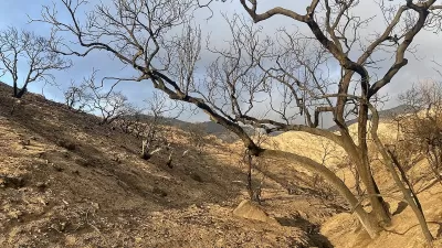
Preserving Altadena’s Trees: A Community Effort to Save a Fire-Damaged Landscape
In the wake of the Eaton Fire, Altadena Green is working to preserve fire-damaged but recoverable trees, advocating for better assessment processes, educating homeowners, and protecting the community’s urban canopy from unnecessary removal.

Annual LA River CleanUp Invites Residents to Protect Local Ecosystems
The Friends of the Los Angeles River will host its 34th Annual LA River CleanUp on October 5, inviting residents to help beautify the river, prevent litter from reaching the ocean, and promote equitable access to green spaces.

Alabama: Trump Terminates Settlements for Black Communities Harmed By Raw Sewage
Trump deemed the landmark civil rights agreement “illegal DEI and environmental justice policy.”

Study: Maui’s Plan to Convert Vacation Rentals to Long-Term Housing Could Cause Nearly $1 Billion Economic Loss
The plan would reduce visitor accommodation by 25% resulting in 1,900 jobs lost.

Planetizen Federal Action Tracker
A weekly monitor of how Trump’s orders and actions are impacting planners and planning in America.

Wind Energy on the Rise Despite Federal Policy Reversal
The Trump administration is revoking federal support for renewable energy, but demand for new projects continues unabated.

Passengers Flock to Caltrain After Electrification
The new electric trains are running faster and more reliably, leading to strong ridership growth on the Bay Area rail system.

Texas Churches Rally Behind ‘Yes in God’s Back Yard’ Legislation
Religious leaders want the state to reduce zoning regulations to streamline leasing church-owned land to housing developers.
Urban Design for Planners 1: Software Tools
This six-course series explores essential urban design concepts using open source software and equips planners with the tools they need to participate fully in the urban design process.
Planning for Universal Design
Learn the tools for implementing Universal Design in planning regulations.
Caltrans
Smith Gee Studio
Institute for Housing and Urban Development Studies (IHS)
City of Grandview
Harvard GSD Executive Education
Toledo-Lucas County Plan Commissions
Salt Lake City
NYU Wagner Graduate School of Public Service