


A publicly available web tool allows access to maps that overlay environmental impacts and the populations they impact (or the populations that manage to avoid such impacts, for that matter).
Heather Hansman shares news about a new tool from the U.S. Environmental Protection Agency called EJSCREEN.
"EJSCREEN, which anyone can use through the EPA's website, pulls in the agency's pollution data and intersects it with census data, so users concretely see where groups and industries are being particularly destructive to the environment, and where people are being disproportionately exposed to pollution," writes Hansman.
Twelve environmental indicators populated the map, including air particulate matter and lead paint. The tool also overlays six demographic indicators. EJSCREEN also generates EJ Indexes, which compile environmental and demographic data for comparisons and perspective.
As for the ambitions behind the tool, Hansman explains why both the EPA and Jane and John Q might find the tool useful: "The EPA is using the tool to identify areas with undue environmental burdens, to pick project areas and to show progress in active cleanup efforts. But it might be even move valuable for individuals and local groups wanting concrete details about what’s going on in their own communities."
FULL STORY: The EPA Has a New Tool For Mapping Where Pollution and Poverty Intersect


Report: ChatGPT Shows Limited Knowledge in Sparsely Populated Areas
Recent research showed bias when using the tool to assess environmental justice issues in various parts of the country.
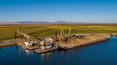
Complaint Blames Bay Delta Ecological Crisis on Racism
Advocates hope to enlist the federal government in forcing state regulators to set clean water standards for the San Francisco Bay Delta.
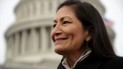
Biden Diversifies Cabinet With EPA Administrator, Interior Secretary Picks
President-elect Biden made two historic cabinet selections: Michael Regan, who heads the North Carolina Department of Environmental Quality, to run the U.S. EPA, and Rep. Deb Haaland of New Mexico, to head the Interior Department.

Alabama: Trump Terminates Settlements for Black Communities Harmed By Raw Sewage
Trump deemed the landmark civil rights agreement “illegal DEI and environmental justice policy.”

Planetizen Federal Action Tracker
A weekly monitor of how Trump’s orders and actions are impacting planners and planning in America.

The 120 Year Old Tiny Home Villages That Sheltered San Francisco’s Earthquake Refugees
More than a century ago, San Francisco mobilized to house thousands of residents displaced by the 1906 earthquake. Could their strategy offer a model for the present?

Ken Jennings Launches Transit Web Series
The Jeopardy champ wants you to ride public transit.

BLM To Rescind Public Lands Rule
The change will downgrade conservation, once again putting federal land at risk for mining and other extractive uses.

Indy Neighborhood Group Builds Temporary Multi-Use Path
Community members, aided in part by funding from the city, repurposed a vehicle lane to create a protected bike and pedestrian path for the summer season.
Urban Design for Planners 1: Software Tools
This six-course series explores essential urban design concepts using open source software and equips planners with the tools they need to participate fully in the urban design process.
Planning for Universal Design
Learn the tools for implementing Universal Design in planning regulations.
Clanton & Associates, Inc.
Jessamine County Fiscal Court
Institute for Housing and Urban Development Studies (IHS)
City of Grandview
Harvard GSD Executive Education
Toledo-Lucas County Plan Commissions
Salt Lake City
NYU Wagner Graduate School of Public Service