


The brain has a complex, ancient relationship with place. Mental maps are the manifestation of our brains' perception of place and wayfinding. These maps can have profound impacts on how residents appreciate, and improve, their neighborhoods.
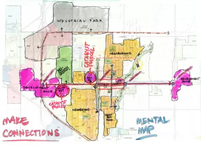
"Place" isn't just a matter of what we see before our eyes. It is also an accumulation of perceptions, histories, and even biases. That's what planner Kevin Lynch proposed in his landmark book The Image of the City, and it's a driving force in the effort to revitalize neighborhoods today.
Though Lynch wasn't a neuroscientist, it turns out that many of his theories are grounded in the physiological processes that the brain uses to orient itself and direct itself through a landscape: "after our brains locate landmarks and create paths, we begin forming edges, districts, and nodes on our mental maps, once again using memories to inform the locational information. This, in essence, are where neighborhoods begin. It's also where things get nice and weird."
"It could be a very deceiving process, because you go by what you see, not by what's really there," Sorin Adam Matei, an associate professor at Purdue who researches mental maps, told Pacific Standard. "People keep saying, location, location, location. That's not objective location, really. It's suggestive location.....A physical location that was nothing 20 years ago, by getting it to the right people and with the right name, all of a sudden becomes hot." In other words, it sometimes takes a new name to erase old memories, for better or worse.
What this means is that revitalizing blighted neighborhoods may rely as much on neuroscience as on public policy.
"Racist practices like redlining, used from the 1930s through the '60s to deny loans, insurance, supermarkets, and health coverage to those residing in certain neighborhoods (a practice that got its name from the literal drawing of red lines on a map to designate what areas to say blanket “nos” to), have predictably led to focused areas of blight. This has led to ensuing protests, persistent negative portrayals, a lack of funding to repair the damage, more protests, more negative portrayals, and so on."
"The first step of making improvements to any neighborhood—including the changes that are designed for original residents—comes from re-defining these quirks in our neurology. "Mental maps cannot be read apart from the stories of those who created them,” Gieseking says. "We need to be careful not only then in how we tell stories but also how we present maps."
FULL STORY: Mental Maps and the Neuroscience of Neighborhood Blight


Analyzing Lynch's City Imageability in the Digital Age
Mahbubur Meenar of Rowan University writes about a recent article he co-authored in the Journal of Planning Education and Research
What the ‘Walk Score’ Misses
A popular walkability assessment omits key factors that impact different demographics and can direct development resources to already wealthy neighborhoods.
Baltimore Program Could Repurpose Thousands of Vacant Housing Units
The city and state are investing $3 billion in rescuing vacant residential properties to promote homeownership and reduce blight.

Alabama: Trump Terminates Settlements for Black Communities Harmed By Raw Sewage
Trump deemed the landmark civil rights agreement “illegal DEI and environmental justice policy.”

Planetizen Federal Action Tracker
A weekly monitor of how Trump’s orders and actions are impacting planners and planning in America.

The 120 Year Old Tiny Home Villages That Sheltered San Francisco’s Earthquake Refugees
More than a century ago, San Francisco mobilized to house thousands of residents displaced by the 1906 earthquake. Could their strategy offer a model for the present?

In Both Crashes and Crime, Public Transportation is Far Safer than Driving
Contrary to popular assumptions, public transportation has far lower crash and crime rates than automobile travel. For safer communities, improve and encourage transit travel.

Report: Zoning Reforms Should Complement Nashville’s Ambitious Transit Plan
Without reform, restrictive zoning codes will limit the impact of the city’s planned transit expansion and could exclude some of the residents who depend on transit the most.

Judge Orders Release of Frozen IRA, IIJA Funding
The decision is a victory for environmental groups who charged that freezing funds for critical infrastructure and disaster response programs caused “real and irreparable harm” to communities.
Urban Design for Planners 1: Software Tools
This six-course series explores essential urban design concepts using open source software and equips planners with the tools they need to participate fully in the urban design process.
Planning for Universal Design
Learn the tools for implementing Universal Design in planning regulations.
Clanton & Associates, Inc.
Jessamine County Fiscal Court
Institute for Housing and Urban Development Studies (IHS)
City of Grandview
Harvard GSD Executive Education
Toledo-Lucas County Plan Commissions
Salt Lake City
NYU Wagner Graduate School of Public Service