


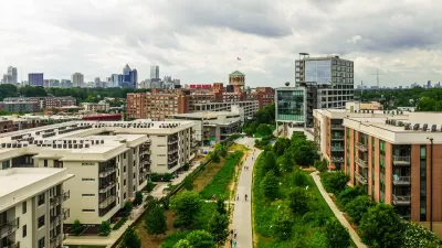
Famously far-flung Atlanta is finding a comforting psychic barrier in the BeltLine, a 45-mile greenbelt in the place of former railroad tracks. The city and developers are trying to make the urban core more functional and attractive.

As in many other cities, young adults in Atlanta are increasingly choosing to live in the urban core rather than in any number of the region's sprawling suburbs. Even so, the contrast between central Atlanta and its outskirts has not, historically, been as stark as those in other cities. Many downtown destinations, like the Underground Atlanta mall, have remained relatively lifeless because of low residential densities and un-walkable streets.
The region, though, is in the process of building 45 miles worth of walkable, bikeable urban infrastructure. When completed, the BeltLine, plus a series of parks, will create a loop around central Atlanta with a 2-4 mile radius connecting 45 neighborhoods and creating a new sense of place for the central city. It has already "proven itself a powerful tool for changing the way people think about Atlanta’s development.
So far, $775 million worth of development has taken place within a half-mile of just one of the segments of the BeltLine. Planners tout developments like the adaptive reuse of a 1925 Sears warehouse and the 138-acre mixed-use Atlanta Station development.
"It isn’t hard to see a geographic correlation between the location of this trend and the outline of the Atlanta BeltLine. Looping the center of the city with a series of paths and parks, it will, when fully completed, pass through 45 close-in neighborhoods that are all within a two- to four-mile radius of downtown. Even in its partially completed early stages, the BeltLine has proven itself a powerful tool for changing the way people think about Atlanta’s development."
FULL STORY: Urbanising Atlanta

Surveying the Results of 150 Years of Persistent Growth in Atlanta
The American Institute of Architects will visit Atlanta this year, a month after the 150th anniversary of the end of the Civil War. What should we know about the city as it exists today?
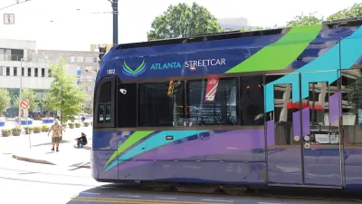
Atlanta Changes Beltline Rail Plan
City officials say they are committed to building rail connections, but are nixing a prior plan to extend the streetcar network.
Beltline Surpasses Annual Affordable Housing Goal
The Atlanta Beltline agency is actively working to prevent the displacement of longtime residents along the trail system, where property values are rising rapidly.

Alabama: Trump Terminates Settlements for Black Communities Harmed By Raw Sewage
Trump deemed the landmark civil rights agreement “illegal DEI and environmental justice policy.”

Planetizen Federal Action Tracker
A weekly monitor of how Trump’s orders and actions are impacting planners and planning in America.

The 120 Year Old Tiny Home Villages That Sheltered San Francisco’s Earthquake Refugees
More than a century ago, San Francisco mobilized to house thousands of residents displaced by the 1906 earthquake. Could their strategy offer a model for the present?

In Both Crashes and Crime, Public Transportation is Far Safer than Driving
Contrary to popular assumptions, public transportation has far lower crash and crime rates than automobile travel. For safer communities, improve and encourage transit travel.

Report: Zoning Reforms Should Complement Nashville’s Ambitious Transit Plan
Without reform, restrictive zoning codes will limit the impact of the city’s planned transit expansion and could exclude some of the residents who depend on transit the most.

Judge Orders Release of Frozen IRA, IIJA Funding
The decision is a victory for environmental groups who charged that freezing funds for critical infrastructure and disaster response programs caused “real and irreparable harm” to communities.
Urban Design for Planners 1: Software Tools
This six-course series explores essential urban design concepts using open source software and equips planners with the tools they need to participate fully in the urban design process.
Planning for Universal Design
Learn the tools for implementing Universal Design in planning regulations.
Clanton & Associates, Inc.
Jessamine County Fiscal Court
Institute for Housing and Urban Development Studies (IHS)
City of Grandview
Harvard GSD Executive Education
Toledo-Lucas County Plan Commissions
Salt Lake City
NYU Wagner Graduate School of Public Service