


FiveThirtyEight and ESPN recently produced a short documentary about the creators of Falling Fruit—a website that maps food sources in cities around the world.
In the first installment of a series of short documentaries, FiveThirtyEight and ESPN Films introduce Evan Welty and Caleb Phillips, creators of the Falling Fruit website—"an open-source, user-generated website that catalogs the location of edible plants all over the world."
As Anna Maria Barry-Jester explains in the FiveThirtyEight post, Falling Fruit "has more than 786,000 data points, each of which represents a location containing one or more plants."
"What’s remarkable about the site," adds Barry Jester, "is that 98 percent of the data points currently come from municipal tree inventories."
The article goes on to address the question asked by the headline: "How many people can the plans in one city feed?" although the answer is not totally clear.
When Planetizen first caught wind of Falling Fruit, Henry Grabar wrote about the potential of the site to help planners design more edible cities.
FULL STORY: How Many People Can The Plants In One City Feed?


An App to Map Free Urban Snacks
A map and website developed by PhD student Ethan Welty and friend Caleb Philip catalogs the cornucopia of edible trees found in the "urban orchards" of two-dozen cities around the world.

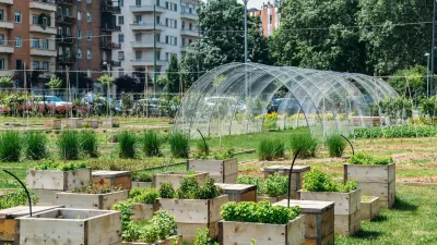
Urban Farming Addressing Hunger (and More) in Pittsburgh
Urban farming provides opportunities to increase food security in addition to other benefits.
Urban Ag Activists Up In Arms About New Study
Researchers looked at the carbon footprint of urban farming versus conventional, and the results were surprising.

Alabama: Trump Terminates Settlements for Black Communities Harmed By Raw Sewage
Trump deemed the landmark civil rights agreement “illegal DEI and environmental justice policy.”

Planetizen Federal Action Tracker
A weekly monitor of how Trump’s orders and actions are impacting planners and planning in America.

The 120 Year Old Tiny Home Villages That Sheltered San Francisco’s Earthquake Refugees
More than a century ago, San Francisco mobilized to house thousands of residents displaced by the 1906 earthquake. Could their strategy offer a model for the present?

USDOT Repeals Emissions Monitoring Rule
A Biden-era regulation required states to report and plan to reduce transportation-related emissions.

CaBi Breaks Ridership Record — Again
Washington D.C.’s bike share system is extremely popular with both residents and visitors.

San Francisco Opens Park on Former Great Highway
The Sunset Dunes park’s grand opening attracted both fans and detractors.
Urban Design for Planners 1: Software Tools
This six-course series explores essential urban design concepts using open source software and equips planners with the tools they need to participate fully in the urban design process.
Planning for Universal Design
Learn the tools for implementing Universal Design in planning regulations.
Clanton & Associates, Inc.
Jessamine County Fiscal Court
Institute for Housing and Urban Development Studies (IHS)
City of Grandview
Harvard GSD Executive Education
Toledo-Lucas County Plan Commissions
Salt Lake City
NYU Wagner Graduate School of Public Service