


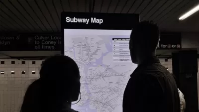
The modernist designer Massimo Vignelli, who created the 1972 version of the New York City Subway map, passed away this week at 83.
To honor Vignelli's passing, Will Doig presents seven creative and lesser-known versions of the New York City Subway system that fans of transit, maps, and New York City (but not necessarily in that order) will enjoy. A sample of the subway system, as presented in these unique representations:
- "When the current New York subway map was introduced in 1979, designer Nobu Siraisi quickly recognized what a mess it was around the Atlantic Avenue station in Brooklyn. So Siraisi redrew that section of the map by hand, in a sketch that never made it off the drawing board, but is somehow gorgeous in its simplicity."
- "For 'I Love NY' in map form, Seoul-based designers Zero Per Zero embeded [sic] New York’s transit system into a heart shape, rendering it cuddlier than it probably has a right to be."
- The article also includes a video of "the New York subway map as string instrument, using the actual train schedule to create the symphony."
FULL STORY: 7 Alternate Versions of the New York City Subway Map

The New York Subway Map, Explained
An interactive feature reveals the origins and design choices of the New York Subway map.
Legendary Map Designer Disses Competition
At a recent talk at the New York City Transit Museum, Massimo Vignelli, designer of the iconic 1972 NYC subway map, discussed his opinions of the subway maps that preceded and followed his groundbreaking design.
NYC Outdoor Dining Could Get a Re-Do
The city council is considering making the al fresco dining program year-round to address cost concerns from small businesses.

Trump Administration Could Effectively End Housing Voucher Program
Federal officials are eyeing major cuts to the Section 8 program that helps millions of low-income households pay rent.

Planetizen Federal Action Tracker
A weekly monitor of how Trump’s orders and actions are impacting planners and planning in America.

Ken Jennings Launches Transit Web Series
The Jeopardy champ wants you to ride public transit.

How Project Connect Would Change ‘The Drag’
A popular — and sometimes deadly — Austin road will exchange car lanes for light rail.

Milwaukee Road to Get Complete Streets Upgrades
The city will reduce vehicle lanes and build a protected multi-use trail including bioswales and other water retention features on its ‘secret highway.’

Tackling Soil Contamination With Nature-Based Solutions
Los Angeles County residents and experts are turning to nature-based methods like bioremediation to address long-standing and fire-exacerbated soil contamination without resorting to costly and disruptive removal.
Urban Design for Planners 1: Software Tools
This six-course series explores essential urban design concepts using open source software and equips planners with the tools they need to participate fully in the urban design process.
Planning for Universal Design
Learn the tools for implementing Universal Design in planning regulations.
Ada County Highway District
Clanton & Associates, Inc.
Jessamine County Fiscal Court
Institute for Housing and Urban Development Studies (IHS)
City of Grandview
Harvard GSD Executive Education
Toledo-Lucas County Plan Commissions
Salt Lake City
NYU Wagner Graduate School of Public Service