


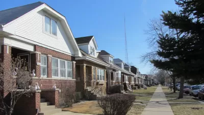
The common perception of New York City is as of a well-integrated city, full of multi-ethnic neighborhoods. But a recent article peeks behind the curtain of the city’s surprising boundaries of racial segregation.
Daniel Kay Hertz provides perhaps surprising findings about the segregation of New York City along racial lines—and how those conditions compare to the segregation in Chicago.
First, Hertz acknowledges the misconceptions of the depth and breadth of segregation in New York City: “virtually every attempt to actually measure racial segregation suggests that New York is one of the most segregated cities in the country,” writes Hertz. But, “[why] is this so surprising? One obvious reason… is that most people’s conception of New York is limited to about 1/2 of Manhattan and maybe 1/6 of Brooklyn, areas that are among the largest job and tourist centers in the world.”
Another reason for the misconception, according to Hertz is the unique qualities of segregation in New York City. “Segregation in New York doesn’t look like segregation in Chicago, or a lot of smaller Rust Belt cities. For one, there just aren’t very many monolithically black neighborhoods left in New York.” In New York, according to Hertz’s analysis, “white folks in New York have still on the whole declined to move to black areas, except for some nibbling along the edges in Harlem and central Brooklyn,” and moreover, “the median black New Yorker lives in a neighborhood with very few white people, and vice versa.”
Hertz’s analysis also includes a very helpful graphic visualization of the city’s segregation, synthesized and animated into .gif form.
FULL STORY: How segregated is New York City?

Mapped: Chicago's Shrinking Middle Class
In 1970, half of the city's census tracts were middle-income. Now, only 16 percent of them remain so. Polarization between the well-off and the poor essentially splits the city in two.

Racial Segregation in U.S. Neighborhoods
Despite the intentions of the nation's fair housing laws, neighborhoods in the United States continue to segregate by race.

Partisan Clustering at the Neighborhood Level
Forget red state versus blue state: a new data analysis and mapping project by The New York Times shows that the political divides in the country can be mapped to the neighborhood level within metropolitan areas.

Study: Maui’s Plan to Convert Vacation Rentals to Long-Term Housing Could Cause Nearly $1 Billion Economic Loss
The plan would reduce visitor accommodation by 25,% resulting in 1,900 jobs lost.

Alabama: Trump Terminates Settlements for Black Communities Harmed By Raw Sewage
Trump deemed the landmark civil rights agreement “illegal DEI and environmental justice policy.”

North Texas Transit Leaders Tout Benefits of TOD for Growing Region
At a summit focused on transit-oriented development, policymakers discussed how North Texas’ expanded light rail system can serve as a tool for economic growth.

Paris Bike Boom Leads to Steep Drop in Air Pollution
The French city’s air quality has improved dramatically in the past 20 years, coinciding with a growth in cycling.

Why Housing Costs More to Build in California Than in Texas
Hard costs like labor and materials combined with ‘soft’ costs such as permitting make building in the San Francisco Bay Area almost three times as costly as in Texas cities.

San Diego County Sees a Rise in Urban Coyotes
San Diego County experiences a rise in urban coyotes, as sightings become prevalent throughout its urban neighbourhoods and surrounding areas.
Urban Design for Planners 1: Software Tools
This six-course series explores essential urban design concepts using open source software and equips planners with the tools they need to participate fully in the urban design process.
Planning for Universal Design
Learn the tools for implementing Universal Design in planning regulations.
Smith Gee Studio
Alamo Area Metropolitan Planning Organization
City of Santa Clarita
Institute for Housing and Urban Development Studies (IHS)
City of Grandview
Harvard GSD Executive Education
Toledo-Lucas County Plan Commissions
Salt Lake City
NYU Wagner Graduate School of Public Service