


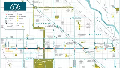
Final plans for what will become the longest elevated park in the world where unveiled this week in Chicago. The 2.7-mile rail-to-trail conversion has been branded as The 606, a nod to the zip code digits shared by the neighborhoods along its route.
"The planned 2.7-mile Bloomingdale Trail and five linked parks -- envisioned as an elevated pedestrian and bicycling corridor splashed with artwork and landscaping -- will assume a new, overarching identity Tuesday when the multi-use recreation system assumes a fresh moniker: The 606." reports Kathy Bergen. "The 606 label represents something virtually all city residents share -- the first three digits of Chicago ZIP codes, which planners hope will connote unity and links among neighborhoods."
In preparation for the project's August groundbreaking, the final plans and implementation schedule were presented at a public meeting held Tuesday. "To start, 38 bridges along the tracks will have to be repaired and rehabilitated, which will result in the some weekend road closures including Ashland, Western and Milwaukee avenues," reports Victoria Johnson. "Attendees also got sneak previews of other plans for The 606 [PDF], including a skate park, event center and stage and an observatory designed to line up with the setting sun."
"The development of a project name came about to dispel confusion surrounding the trail, which will run atop an abandoned 16-foot-high rail bed that runs above Bloomingdale Avenue, which is about 1800 [sic] north," says Bergen. "It stretches from Ashland Avenue on the east to Ridgeway Avenue on the west, linking Bucktown, Wicker Park, Logan Square and Humboldt Park."
"Lots of people thought it was in Bloomingdale, Ill., or many times people would call it the Bloomington Trail," said Beth White, director of the Trust for Public Land's Chicago office.
FULL STORY: Next step for Bloomingdale Trail: Creating an identity

Meet the 606: Chicago's New Elevated Bikeway and Park
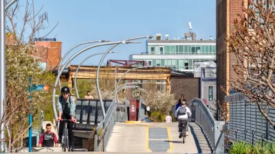
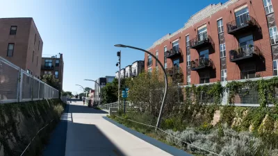
Following in the footsteps of the High Line in New York City, Chicago opened a 2.7-mile elevated park, which has already been extremely popular in its first week. Here we round up the initial reactions to The 606, as the new park is called.
Don't Call it The 606: Chicago's Popular Linear Park Gets a New Name
The Chicago Park District wants to be extra sure we're all clear on this.
More Cities Pressing Pause on Development as Gentrification, Displacement Concerns Persist
Chicago and Atlanta both approved development moratoriums in areas surrounding new urban amenities this year. Other cities could soon add to the number.

Trump Administration Could Effectively End Housing Voucher Program
Federal officials are eyeing major cuts to the Section 8 program that helps millions of low-income households pay rent.

Planetizen Federal Action Tracker
A weekly monitor of how Trump’s orders and actions are impacting planners and planning in America.

The 120 Year Old Tiny Home Villages That Sheltered San Francisco’s Earthquake Refugees
More than a century ago, San Francisco mobilized to house thousands of residents displaced by the 1906 earthquake. Could their strategy offer a model for the present?

HSR Reaches Key Settlement in Northern California City
The state’s high-speed rail authority reached an agreement with Millbrae, a key city on the train’s proposed route to San Francisco.

Washington State Legislature Passes Parking Reform Bill
A bill that would limit parking requirements for new developments is headed to the governor’s desk.

Missouri Law Would Ban Protections for Housing Voucher Users
A state law seeks to overturn source-of-income discrimination bans passed by several Missouri cities.
Urban Design for Planners 1: Software Tools
This six-course series explores essential urban design concepts using open source software and equips planners with the tools they need to participate fully in the urban design process.
Planning for Universal Design
Learn the tools for implementing Universal Design in planning regulations.
Ada County Highway District
Clanton & Associates, Inc.
Jessamine County Fiscal Court
Institute for Housing and Urban Development Studies (IHS)
City of Grandview
Harvard GSD Executive Education
Toledo-Lucas County Plan Commissions
Salt Lake City
NYU Wagner Graduate School of Public Service