


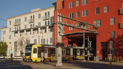
Before the first line of the multi-billion dollar FasTracks regional transit expansion opens to the public, developers are clamoring to build near Denver area stations. In a city that was beset by sprawl for a half-century, the shift is good news.
Eric Jaffe looks at a new report that describes the effect that FasTracks, the ambitious plan to "expand transit service in three existing corridors, create new service in six other corridors, and develop Denver's Union Station into a multi-modal regional transportation hub," has had on the area's land use patterns.
"In a recent special issue of the journal Cities, geographers Keith Ratner of Salem State University and Andrew Goetz of the University of Denver report that transit-oriented development in the FasTracks era has already had a measurable effect on the character of the city. After analyzing TOD data from around the city, Ratner and Goetz conclude that increased density near transit stations — one of the primary objectives of the regional plan — is 'clearly evident'..."
"Ratner and Goetz attribute much of that change to a successful TOD campaign that focused on five key goals: placing homes, jobs, and retail near transit; creating a mixture of transportation, housing, and shopping options; capturing some of the business value of transit for the city; emphasizing "place-making" strategies; and ensuring that transit stations were entry portals to a truly regional network," says Jaffe.
"All told, Denver has created some 18,000 residential units, 5.3 million square feet of retail, and 5.4 million square feet of office space within a half mile of transit station, Ratner and Goetz report."
FULL STORY: After Decades of Sprawl, Density Comes to Denver

California Bill Aims to Boost TOD
A bill proposed by Sen. Scott Wiener would exempt transit agencies from zoning rules near ‘high-quality’ transit stops and allow denser transit-oriented development.

Denver Pauses Multifamily Development in Westside Neighborhoods Amidst Gentrification Concerns
City officials say the pause on permits for redevelopment projects aims to stop the displacement of long-term residents.

Proposed San Diego Code Update Seeks to Increase Density Near Transit
A set of proposed updates to the city’s development code would expand TOD zones and encourage more backyard dwellings.

Alabama: Trump Terminates Settlements for Black Communities Harmed By Raw Sewage
Trump deemed the landmark civil rights agreement “illegal DEI and environmental justice policy.”

Planetizen Federal Action Tracker
A weekly monitor of how Trump’s orders and actions are impacting planners and planning in America.

The 120 Year Old Tiny Home Villages That Sheltered San Francisco’s Earthquake Refugees
More than a century ago, San Francisco mobilized to house thousands of residents displaced by the 1906 earthquake. Could their strategy offer a model for the present?

Ken Jennings Launches Transit Web Series
The Jeopardy champ wants you to ride public transit.

BLM To Rescind Public Lands Rule
The change will downgrade conservation, once again putting federal land at risk for mining and other extractive uses.

Indy Neighborhood Group Builds Temporary Multi-Use Path
Community members, aided in part by funding from the city, repurposed a vehicle lane to create a protected bike and pedestrian path for the summer season.
Urban Design for Planners 1: Software Tools
This six-course series explores essential urban design concepts using open source software and equips planners with the tools they need to participate fully in the urban design process.
Planning for Universal Design
Learn the tools for implementing Universal Design in planning regulations.
Clanton & Associates, Inc.
Jessamine County Fiscal Court
Institute for Housing and Urban Development Studies (IHS)
City of Grandview
Harvard GSD Executive Education
Toledo-Lucas County Plan Commissions
Salt Lake City
NYU Wagner Graduate School of Public Service