


Recently a destination for luxury development, New York's waterfront has historically been home to the city's poor. When Sandy inundated these vulnerable populations, it "looked like a perverse stroke of urban planning," writes Jonathan Mahler.
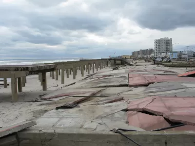
"How is it possible that the same winding, 538-mile coastline that has recently been colonized by condominium developers chasing wealthy New Yorkers, themselves chasing waterfront views, had been, for decades, a catch basin for many of the city’s poorest residents?" asks Mahler. In an essay for the Times, he answers his question by surveying the history of "accident, grand vision and political expedience," that led to public housing projects sprouting in close proximity to the water in such areas as the Rockaways, Coney Island, Red Hook and Alphabet City.
"New York started building housing projects on the waterfront because that’s where its poorest citizens happened to live. It continued because that’s where space was most readily available. Finally, it built them there because that’s where its projects already were."
Smack dab in the middle of this sequence sits Robert Moses. "It’s impossible to talk about the landscape of modern New York without talking about Moses," says Mahler, "who leveraged his position as head of the Mayor’s Committee on Slum Clearance to mass-produce thousands of units of high-rise public housing, often near the shoreline. His shadow looms over much of the havoc wreaked by the storm."
FULL STORY: How the Coastline Became a Place to Put the Poor


Alabama: Trump Terminates Settlements for Black Communities Harmed By Raw Sewage
Trump deemed the landmark civil rights agreement “illegal DEI and environmental justice policy.”

Planetizen Federal Action Tracker
A weekly monitor of how Trump’s orders and actions are impacting planners and planning in America.

The 120 Year Old Tiny Home Villages That Sheltered San Francisco’s Earthquake Refugees
More than a century ago, San Francisco mobilized to house thousands of residents displaced by the 1906 earthquake. Could their strategy offer a model for the present?

Indy Neighborhood Group Builds Temporary Multi-Use Path
Community members, aided in part by funding from the city, repurposed a vehicle lane to create a protected bike and pedestrian path for the summer season.

Congestion Pricing Drops Holland Tunnel Delays by 65 Percent
New York City’s contentious tolling program has yielded improved traffic and roughly $100 million in revenue for the MTA.

In Both Crashes and Crime, Public Transportation is Far Safer than Driving
Contrary to popular assumptions, public transportation has far lower crash and crime rates than automobile travel. For safer communities, improve and encourage transit travel.
Urban Design for Planners 1: Software Tools
This six-course series explores essential urban design concepts using open source software and equips planners with the tools they need to participate fully in the urban design process.
Planning for Universal Design
Learn the tools for implementing Universal Design in planning regulations.
Clanton & Associates, Inc.
Jessamine County Fiscal Court
Institute for Housing and Urban Development Studies (IHS)
City of Grandview
Harvard GSD Executive Education
Toledo-Lucas County Plan Commissions
Salt Lake City
NYU Wagner Graduate School of Public Service