


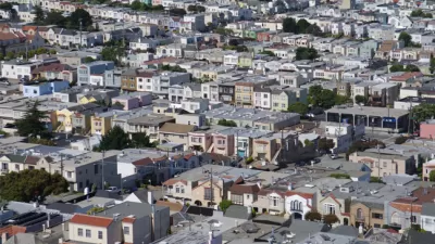
Census data reveals that California is the most urbanized state, with the most dense urban areas. But in California, sprawl, density, crowding, and urbanism are not always what they seem. Fortunately, a new law may help planners make sense of it all.
Josh Stephens delves deeper into the causes and implications of recent census data that ranks the California communities of Los Angeles-Long Beach-Anaheim, San Francisco-Oakland, San Jose, and Delano, as the top four densest urban areas in the entire country.
"Setting aside Delano's unexpected star turn, none of this should come as a surprise to planners in California (which also happens to be the "most urban" state, with 95% urban residency). Density is what happens when you build freeways all over the place and everyone gets to live all over the place. For all the objective connotations of these figures, there's no doubt that there's plenty of room for interpretation, which can have deep implications for public policy."
"If cities implement the tenets of SB 375's Sustainable Communities Strategies--regional plans being drawn up by the metropolitan planning organizations of San Diego, Sacramento, the Bay Area, and Southern California (Los Angeles)--then density may no longer be hidden. It will be plain to see in the streetscapes. And if California residents can accept the fact that we are, indeed, an urban state, maybe, by the time we hit 8,000 per square mile, we'll look like one too."
Thanks to Josh Stephens
FULL STORY: Parsing California's Density Bombshell in 2010 Census Data

SPUR: The Bay Area Has A Sprawl Problem
SPUR states its case clearly by announcing, “We believe cities are the key to our future” at the opening of a new report called “SPUR’s Agenda for Change.”
New Census Numbers Detail Surprising Facts About Urban Density
John King considers a new report released by the Census Bureau on Monday, which finds that of the ten most densely populated urbanized areas in the United States, nine are in the West.
Density and Disorder: The Imaginary Link
A recent article tries to tie public transit and walkability to social disorder — but in fact, sprawling Sunbelt cities like Memphis are as likely to have high crime rates as transit-rich metropolises such as New York and San Francisco.

Alabama: Trump Terminates Settlements for Black Communities Harmed By Raw Sewage
Trump deemed the landmark civil rights agreement “illegal DEI and environmental justice policy.”

Planetizen Federal Action Tracker
A weekly monitor of how Trump’s orders and actions are impacting planners and planning in America.

The 120 Year Old Tiny Home Villages That Sheltered San Francisco’s Earthquake Refugees
More than a century ago, San Francisco mobilized to house thousands of residents displaced by the 1906 earthquake. Could their strategy offer a model for the present?

Ken Jennings Launches Transit Web Series
The Jeopardy champ wants you to ride public transit.

BLM To Rescind Public Lands Rule
The change will downgrade conservation, once again putting federal land at risk for mining and other extractive uses.

Indy Neighborhood Group Builds Temporary Multi-Use Path
Community members, aided in part by funding from the city, repurposed a vehicle lane to create a protected bike and pedestrian path for the summer season.
Urban Design for Planners 1: Software Tools
This six-course series explores essential urban design concepts using open source software and equips planners with the tools they need to participate fully in the urban design process.
Planning for Universal Design
Learn the tools for implementing Universal Design in planning regulations.
Clanton & Associates, Inc.
Jessamine County Fiscal Court
Institute for Housing and Urban Development Studies (IHS)
City of Grandview
Harvard GSD Executive Education
Toledo-Lucas County Plan Commissions
Salt Lake City
NYU Wagner Graduate School of Public Service