


Ever wonder why Los Angeles looks the way it does? Jeremy Rosenberg examines 1908's Residence District Ordinance as one of the principal culprits in the newest addition to the "Laws That Shaped L.A." series.
A common misconception has it that Los Angeles is an "unplanned" city. To disprove this, one must look no further than any of the dozens of influential architectural and development histories written about the city, the forthcoming book Planning Los Angeles, or to the Residence District Ordinance (RDO) adopted by the Los Angeles City Council in 1908.
In fact Los Angeles has been a land use and planning pioneer, as the RDO can attest: "'Los Angeles was one of the first large cities in the U.S. to adopt a kind of modern zoning to keep the industrial away from the residential,'" [Occidental College professor Mark] Vallianatos says. Indeed, the Residence District Ordinance is sometimes credited as being the nation's first such broad land use edict," notes Rosenberg.
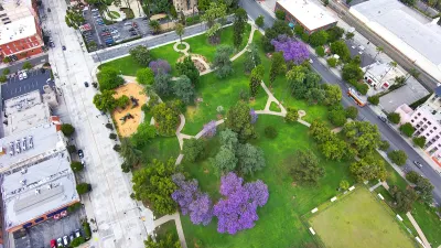
While the ordinance cannot be entirely blamed for the sprawl that characterizes the contemporary city, it certainly contributed to the horizontal growth that followed. Speculating about the form of Los Angeles without the segregating effects of the single-use zoning ordinance, which of course became commonplace across the country, Vallianatos sees a denser city.
"If the city would have more mixed use, with people living closer to retail and workplaces, Los Angeles would feel like another city, with less of its land area dedicated to low density, single family residential neighborhoods, and more streets with shops and businesses on the ground floor and homes above."
FULL STORY: The Roots of Sprawl: Why We Don't Live Where We Work

Los Angeles County Invests in Wildfire Recovery for Parks, Trails, and Open Space
The $4.25 million RESTORE Program supports the recovery of parks, trails, and open spaces damaged by the January 2025 wildfires through targeted grants that promote community healing, wildfire resilience, and equitable access to nature.
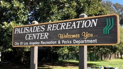
Private Donations Propel Early Restoration of Palisades Playground
Los Angeles has secured over $1.3 million in private funding to restore the Pacific Palisades playground months ahead of schedule, creating a modern, accessible space that supports community healing after recent wildfires.

Rethinking Wildfire Defense: How a Landscape Approach Can Protect Neighborhoods
Post-fire analysis of the Eaton Fire reveals that a landscape approach — including fire-resistant vegetation, home hardening, and strategic planning — can help reduce wildfire risk, challenging assumptions that trees and plants are primary fire hazards.

Alabama: Trump Terminates Settlements for Black Communities Harmed By Raw Sewage
Trump deemed the landmark civil rights agreement “illegal DEI and environmental justice policy.”

Planetizen Federal Action Tracker
A weekly monitor of how Trump’s orders and actions are impacting planners and planning in America.

The 120 Year Old Tiny Home Villages That Sheltered San Francisco’s Earthquake Refugees
More than a century ago, San Francisco mobilized to house thousands of residents displaced by the 1906 earthquake. Could their strategy offer a model for the present?

In Both Crashes and Crime, Public Transportation is Far Safer than Driving
Contrary to popular assumptions, public transportation has far lower crash and crime rates than automobile travel. For safer communities, improve and encourage transit travel.

Report: Zoning Reforms Should Complement Nashville’s Ambitious Transit Plan
Without reform, restrictive zoning codes will limit the impact of the city’s planned transit expansion and could exclude some of the residents who depend on transit the most.

Judge Orders Release of Frozen IRA, IIJA Funding
The decision is a victory for environmental groups who charged that freezing funds for critical infrastructure and disaster response programs caused “real and irreparable harm” to communities.
Urban Design for Planners 1: Software Tools
This six-course series explores essential urban design concepts using open source software and equips planners with the tools they need to participate fully in the urban design process.
Planning for Universal Design
Learn the tools for implementing Universal Design in planning regulations.
Clanton & Associates, Inc.
Jessamine County Fiscal Court
Institute for Housing and Urban Development Studies (IHS)
City of Grandview
Harvard GSD Executive Education
Toledo-Lucas County Plan Commissions
Salt Lake City
NYU Wagner Graduate School of Public Service