


Post-fire analysis of the Eaton Fire reveals that a landscape approach — including fire-resistant vegetation, home hardening, and strategic planning — can help reduce wildfire risk, challenging assumptions that trees and plants are primary fire hazards.
The Eaton Fire in Altadena, California, highlights the growing threat of wildfires in the Wildland Urban Interface (WUI) due to climate change and inadequate infrastructure. As Ronnie Siegel explains in this article, while initial assumptions often blame vegetation, post-fire evidence suggests trees and plants were not the primary culprits in the fire's spread—in fact, many served as protective barriers. A landscape-based approach to wildfire risk reduction involves limiting new development in the WUI, creating vegetated buffer zones, and making urban areas more fire-resistant through "home hardening" and updated land-use planning strategies. These measures, when implemented at both the individual and community levels, can help minimize future fire damage.
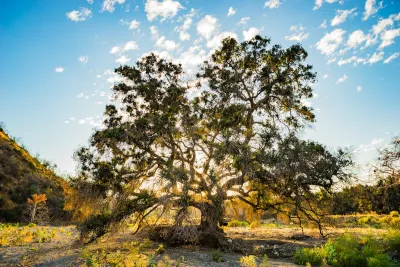
The Eaton Fire, fueled by drought-stricken chaparral and extreme Santa Ana winds, was likely ignited by a spark from power lines and rapidly spread via wind-driven embers. Thousands of homes burned, largely due to their flammability and close proximity to one another, overwhelming the region’s water supply and firefighting resources. Yet, in many places, native and well-watered trees — such as oaks and deodars — survived and even shielded homes from embers. Observations and LiDAR imaging suggest that fire-adapted and water-retentive plants, both native and non-native, can provide significant protection, challenging current defensible space guidelines that label many of these species as hazards.
Moving forward, experts recommend revisiting and updating these guidelines using on-the-ground data and further research into plant water retention and fire resistance. Collaboration among scientists, fire professionals, planners, and residents will be essential to determine the most effective plant species, landscape designs, and urban green buffer zones. Satellite imagery and post-fire mapping also indicate that urban vegetation — if properly maintained and irrigated — can slow wildfire spread and protect communities. By integrating fire science with landscape planning, we can build more resilient neighborhoods and reduce the risk of future wildfire disasters.
FULL STORY: With a Landscape Approach, We Can Reduce the Risk of the Next Wildfire Disaster


Rethinking Los Angeles Landscapes: Balancing Iconic Trees and Fire Resilience
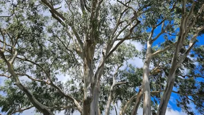
L.A. must balance fire resilience with ecological preservation by gradually replacing flammable non-native plants like eucalyptus and palm trees with native and fire-resistant species while rethinking urban landscapes and land management practices.
Rethinking Fire-Resistant Landscaping: Which Trees Should We Plant?
Fire experts emphasize the need to replace highly flammable trees like Mexican fan palms and eucalyptus with fire-resistant species such as oak, sycamore, and toyon, while also strengthening home fire defenses to reduce wildfire risks in California.
Resilient Communities, Healthy Ecosystems: A Balanced Approach to Wildfires
Effective wildfire mitigation in California requires a holistic approach that goes beyond large-scale vegetation removal, emphasizing home hardening, defensible space, strategic planning, and reducing human-caused ignitions.

Study: Maui’s Plan to Convert Vacation Rentals to Long-Term Housing Could Cause Nearly $1 Billion Economic Loss
The plan would reduce visitor accommodation by 25,% resulting in 1,900 jobs lost.

North Texas Transit Leaders Tout Benefits of TOD for Growing Region
At a summit focused on transit-oriented development, policymakers discussed how North Texas’ expanded light rail system can serve as a tool for economic growth.

Why Should We Subsidize Public Transportation?
Many public transit agencies face financial stress due to rising costs, declining fare revenue, and declining subsidies. Transit advocates must provide a strong business case for increasing public transit funding.

How to Make US Trains Faster
Changes to boarding platforms and a switch to electric trains could improve U.S. passenger rail service without the added cost of high-speed rail.

Columbia’s Revitalized ‘Loop’ Is a Hub for Local Entrepreneurs
A focus on small businesses is helping a commercial corridor in Columbia, Missouri thrive.

Invasive Insect Threatens Minnesota’s Ash Forests
The Emerald Ash Borer is a rapidly spreading invasive pest threatening Minnesota’s ash trees, and homeowners are encouraged to plant diverse replacement species, avoid moving ash firewood, and monitor for signs of infestation.
Urban Design for Planners 1: Software Tools
This six-course series explores essential urban design concepts using open source software and equips planners with the tools they need to participate fully in the urban design process.
Planning for Universal Design
Learn the tools for implementing Universal Design in planning regulations.
City of Santa Clarita
Ascent Environmental
Institute for Housing and Urban Development Studies (IHS)
City of Grandview
Harvard GSD Executive Education
Toledo-Lucas County Plan Commissions
Salt Lake City
NYU Wagner Graduate School of Public Service