


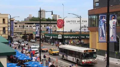
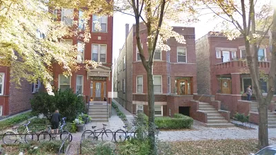
A few days ago, I was in a Chicago neighborhood called Lincoln Square, on Lincoln Avenue just south of Lawrence Avenue. Lincoln Avenue looks like many posh urban neighborhoods- narrow, walkable streets inhabited by gelato-eating, prosperous-looking people. Even on a weeknight, the shops and streets of Lincoln Square betrayed no evidence of a recession.*

A few days ago, I was in a Chicago neighborhood called Lincoln Square, on Lincoln Avenue just south of Lawrence Avenue. Lincoln Avenue looks like many posh urban neighborhoods- narrow, walkable streets inhabited by gelato-eating, prosperous-looking people. Even on a weeknight, the shops and streets of Lincoln Square betrayed no evidence of a recession.*
Lincoln intersects with Lawrence Avenue just a block from the core of Lincoln Square. Lawrence Avenue resembles a suburb more than it resembles Lincoln Square; it is six lanes wide (though unlike in most suburbs, two of them are used for parking), and some shops are behind parking lots. But Lawrence's retail is far less prosperous than that of Lincoln; a good number of Lawrence's storefronts seemed to be vacant, and others were occupied by dollar stores and other non-carriage trade businesses.**
Both Lincoln Avenue and Lawrence Avenue have the same housing stock and thus the same neighbors, the same city government (and thus the same tax rates and school districts) and the same distance from downtown (about seven miles). Thus, these two intersecting streets constitute the perfect controlled experiment on the popularity of walkable urbanism. If people basically liked shopping on car-oriented speedways, Lawrence would have fewer vacant storefronts than Lincoln. Yet the opposite is true. It follows that where everything else is equal, shoppers prefer walkable urbanism to car-oriented suburbanism.
At this point, readers may be asking themselves: why, then, do some suburbs continue to prosper? Because not everything else is equal: an unwalkable suburb may be further away from troubled neighborhoods (usually leading to more prestigous schools and less crime), in a less poverty-packed jurisdiction (thus leading to lower taxes), or have a newer housing stock. Thus, not every suburb will look as scruffy as Lincoln Square.
But the tale of these two adjacent streets nevertheless tells us something: that city life with walkability is appealing to American consumers, while city life with less walkability is anything but.
*For a few pictures of Lincoln Square, see
http://atlantaphotos.fotopic.net/p66205703.html
http://atlantaphotos.fotopic.net/p66205709.html
http://atlantaphotos.fotopic.net/p66205702.html
**Although I took no pictures of Lawrence, you can see the street by going to the 2200-2600 blocks of West Lawrence Avenue on Google Street View.

Chicago Plans ‘Better Streets for Buses’
The city of Chicago is taking first steps toward a commitment to better bus service in the design and configuration of the city's streets.
Report Links Housing Growth and Climate Resilience
Data from three U.S. metro areas show a failure to address land use and sprawl as a key factor driving climate change.
Research Shows '15-Minute City' Not Enough to Guarantee Equity
A study of Chicago neighborhoods showed that access to urban amenities does not necessarily correlate with improved economic outcomes.

Alabama: Trump Terminates Settlements for Black Communities Harmed By Raw Sewage
Trump deemed the landmark civil rights agreement “illegal DEI and environmental justice policy.”

Study: Maui’s Plan to Convert Vacation Rentals to Long-Term Housing Could Cause Nearly $1 Billion Economic Loss
The plan would reduce visitor accommodation by 25% resulting in 1,900 jobs lost.

Planetizen Federal Action Tracker
A weekly monitor of how Trump’s orders and actions are impacting planners and planning in America.

Waymo Gets Permission to Map SF’s Market Street
If allowed to operate on the traffic-restricted street, Waymo’s autonomous taxis would have a leg up over ride-hailing competitors — and counter the city’s efforts to grow bike and pedestrian on the thoroughfare.

Parklet Symposium Highlights the Success of Shared Spaces
Parklets got a boost during the Covid-19 pandemic, when the concept was translated to outdoor dining programs that offered restaurants a lifeline during the shutdown.

Federal Homelessness Agency Places Entire Staff on Leave
The U.S. Interagency Council on Homelessness is the only federal agency dedicated to preventing and ending homelessness.
Urban Design for Planners 1: Software Tools
This six-course series explores essential urban design concepts using open source software and equips planners with the tools they need to participate fully in the urban design process.
Planning for Universal Design
Learn the tools for implementing Universal Design in planning regulations.
Caltrans
Smith Gee Studio
Institute for Housing and Urban Development Studies (IHS)
City of Grandview
Harvard GSD Executive Education
Toledo-Lucas County Plan Commissions
Salt Lake City
NYU Wagner Graduate School of Public Service