


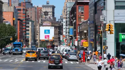
New York City has GPS data from tens of thousands of taxis and is beginning to mine that information to improve its streets. We talked to some transportation experts for their ideas on how to use it.
Sam Schwartz, former commissioner at the NY DOT, had this interesting idea:
"One possible use of the taxi data is to identify clusters of origins and destinations where it can be demonstrated that walking travel times are competitive or can be made competitive to taxi travel times. Then the city can try to make those walking trips more inviting with street designs, lighting, policing, changing signal timing to speed the walking trip, etc. Next, the city should publicize the competitiveness of walking for these trips."
Many more ideas over at Streetsblog.
Thanks to Noah Kazis
FULL STORY: What Can Taxi Data Tell Us About NYC Streets?

Congestion Pricing to Balance Out Mobility Systems
The goal of transportation networks should be to provide integrated and efficient services, which requires looking beyond particular modes.
In Manhattan, Shopping and Driving Don't Mix
The New York City Department of Transportation's yearly statistical smorgasbord adds a new tool: neighborhood travel profiles showing how people arrived in eight neighborhoods. In many of them, the number of drivers was in the single digits.
Traffic Survey Paints Picture of New York City Congestion
Through a survey of New York City taxis with GPS tracking devices, the city has created a database of speeds and routes that gives them a clear picture of the state of traffic in the city.

Alabama: Trump Terminates Settlements for Black Communities Harmed By Raw Sewage
Trump deemed the landmark civil rights agreement “illegal DEI and environmental justice policy.”

Planetizen Federal Action Tracker
A weekly monitor of how Trump’s orders and actions are impacting planners and planning in America.

The 120 Year Old Tiny Home Villages That Sheltered San Francisco’s Earthquake Refugees
More than a century ago, San Francisco mobilized to house thousands of residents displaced by the 1906 earthquake. Could their strategy offer a model for the present?

Ken Jennings Launches Transit Web Series
The Jeopardy champ wants you to ride public transit.

BLM To Rescind Public Lands Rule
The change will downgrade conservation, once again putting federal land at risk for mining and other extractive uses.

Indy Neighborhood Group Builds Temporary Multi-Use Path
Community members, aided in part by funding from the city, repurposed a vehicle lane to create a protected bike and pedestrian path for the summer season.
Urban Design for Planners 1: Software Tools
This six-course series explores essential urban design concepts using open source software and equips planners with the tools they need to participate fully in the urban design process.
Planning for Universal Design
Learn the tools for implementing Universal Design in planning regulations.
Clanton & Associates, Inc.
Jessamine County Fiscal Court
Institute for Housing and Urban Development Studies (IHS)
City of Grandview
Harvard GSD Executive Education
Toledo-Lucas County Plan Commissions
Salt Lake City
NYU Wagner Graduate School of Public Service