


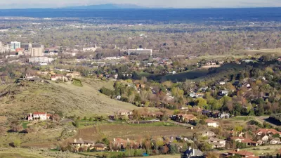
Growth rates in Waco, Texas, have planners concerned that the region won't be able to afford the necessary roads and services the new sprawl will require.
"Local planners say that if current growth patterns continue over the next 25 years, it will cost $3 billion to build roads to new growth areas. And they can no longer depend on state and federal governments to do the heavy lifting."
"In recent years, Greater Waco has seen an unprecedented amount of scattered low-density development, known as urban sprawl. Between 1995 and 2005, 72 percent of development acreage in McLennan County was outside the recognized urban boundaries of Waco and its suburbs, according to the Waco Metropolitan Planning Organization."
"The county's population grew 11 percent during those 10 years, but developed acreage increased by 22 percent, suggesting a pattern of growth that is half as dense as the historic norm."
"A December 2007 study commissioned by the Waco MPO predicted that if current growth patterns continue, 45.7 square miles of land would be consumed by 2030, based on a population increase conservatively estimated at 45,319."
FULL STORY: Waco leaders address issues dealing with urban sprawl


Florida Law Would Change the Definition of ‘Sprawl’
One quick way to build sprawl.

The Pandemic Population Picture Comes Into Focus
Big U.S. cities lost population as the pandemic loitered into its second year. Suburban cities in Idaho, Arizona, Texas, and Florida grew the fastest during that time.
Different Approaches to Fast Growth in Idaho's Treasure Valley
Three cities on the periphery of the fast-growing Treasure Valley showcase different approaches to a sudden influx of newcomers.

Trump Administration Could Effectively End Housing Voucher Program
Federal officials are eyeing major cuts to the Section 8 program that helps millions of low-income households pay rent.

Planetizen Federal Action Tracker
A weekly monitor of how Trump’s orders and actions are impacting planners and planning in America.

Ken Jennings Launches Transit Web Series
The Jeopardy champ wants you to ride public transit.

Milwaukee Road to Get Complete Streets Upgrades
The city will reduce vehicle lanes and build a protected multi-use trail including bioswales and other water retention features on its ‘secret highway.’

Tackling Soil Contamination With Nature-Based Solutions
Los Angeles County residents and experts are turning to nature-based methods like bioremediation to address long-standing and fire-exacerbated soil contamination without resorting to costly and disruptive removal.

Rebuilding Smarter: How LA County Is Guiding Fire-Ravaged Communities Toward Resilience
Los Angeles County is leading a coordinated effort to help fire-impacted communities rebuild with resilience by providing recovery resources, promoting fire-wise design, and aligning reconstruction with broader sustainability and climate goals.
Urban Design for Planners 1: Software Tools
This six-course series explores essential urban design concepts using open source software and equips planners with the tools they need to participate fully in the urban design process.
Planning for Universal Design
Learn the tools for implementing Universal Design in planning regulations.
Ada County Highway District
Clanton & Associates, Inc.
Jessamine County Fiscal Court
Institute for Housing and Urban Development Studies (IHS)
City of Grandview
Harvard GSD Executive Education
Toledo-Lucas County Plan Commissions
Salt Lake City
NYU Wagner Graduate School of Public Service