


Cartographer Mark Newman's new book, 'The Atlas of the Real World', includes maps that show more than just 'how many acres there are in a country.' Malaria cases and health care spending per capita are among some of Newman's unconventional maps.
"'Maps can be misleading, absolutely," says Mark Newman of the University of Michigan, who is a co-author of the book The Atlas of the Real World: Mapping the Way We Live. "Your standard map of the world makes the North Pole look huge and the equator look very small. And we just accept it the way it is.'"
"Newman is perhaps best known for his electoral maps. Traditionally, the view is a virtual sea of red through the middle of the country, flanked by blue coasts. Looking at big red Montana, one may think it has much more influence than little blue New York – a third of Montana's size.
The reality is that New York has more than 10 times the number of electoral votes, because its population is so much bigger."
"Newman's new book takes this concept and applies it to the entire globe. On a map of car exports per capita, for example, Japan becomes gigantic - bigger than most continents - by virtue of its vast numbers of automobile exports."
Thanks to Franny Ritchie

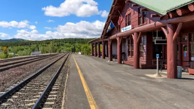
More Passenger Rail Coming to Montana
Planning is underway to restore a 45-year-defunct regional passenger rail line connecting southern Montana to Billings and Amtrak’s east-west Empire Builder line from Seattle to Chicago.
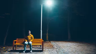
Elevating the ‘Small Stuff’ in Urban Design
Chuck Wolfe recaps arguments in favor of increased attention to incidentals — from benches to bollards — in urban development practices.
Los Angeles County Initiates Effort to Advance Equity in Infrastructure
L.A. County Public Works has launched an initiative to center equity in all of its processes, programming, and services as it plans, designs, builds, and maintains modern infrastructure that uplifts all communities of the county.

Alabama: Trump Terminates Settlements for Black Communities Harmed By Raw Sewage
Trump deemed the landmark civil rights agreement “illegal DEI and environmental justice policy.”

Planetizen Federal Action Tracker
A weekly monitor of how Trump’s orders and actions are impacting planners and planning in America.

The 120 Year Old Tiny Home Villages That Sheltered San Francisco’s Earthquake Refugees
More than a century ago, San Francisco mobilized to house thousands of residents displaced by the 1906 earthquake. Could their strategy offer a model for the present?

Ken Jennings Launches Transit Web Series
The Jeopardy champ wants you to ride public transit.

BLM To Rescind Public Lands Rule
The change will downgrade conservation, once again putting federal land at risk for mining and other extractive uses.

Indy Neighborhood Group Builds Temporary Multi-Use Path
Community members, aided in part by funding from the city, repurposed a vehicle lane to create a protected bike and pedestrian path for the summer season.
Urban Design for Planners 1: Software Tools
This six-course series explores essential urban design concepts using open source software and equips planners with the tools they need to participate fully in the urban design process.
Planning for Universal Design
Learn the tools for implementing Universal Design in planning regulations.
Clanton & Associates, Inc.
Jessamine County Fiscal Court
Institute for Housing and Urban Development Studies (IHS)
City of Grandview
Harvard GSD Executive Education
Toledo-Lucas County Plan Commissions
Salt Lake City
NYU Wagner Graduate School of Public Service