


Randal O’Toole’s recent policy study from the Cato Institute, “Roadmap to Gridlock” is s worthy read for all professional planners, no matter what their ideological or professional stripe. Undoubtedly, most planners probably consider someone who maintains a blog called the “Antiplanner” more of a bomb thrower than a serious policy analyst. But this dismissive attitude throws an awful lot of good work by the road side, and a good example of that is O’Toole’s “Roadmap to Gridlock.”

Randal O'Toole's recent policy study from the Cato Institute, "Roadmap to Gridlock" is s worthy read for all professional planners, no matter what their ideological or professional stripe. Undoubtedly, most planners probably consider someone who maintains a blog called the "Antiplanner" more of a bomb thrower than a serious policy analyst. But this dismissive attitude throws an awful lot of good work by the road side, and a good example of that is O'Toole's "Roadmap to Gridlock."
O'Toole, for those willing to go beyond the oped tag line, is no stranger to planning. Before leaping into urban planning and transportation in the mid-1990s, he was a leading figure in the reforming public lands management. He made a career out of reviewing, updating, and revising plans for forests and public lands, and had a respected national reputation for his work. "Roadmap to Gridlock" then should be of more than passing interest to professional planners.
For those with thin skins, go directly to pages 7-13 on "Procedural Problems with Transportation Plans." This section should be required reading in every planning course, whether it focuses on transportation planning or not. The reason is simple: O'Toole conducts sound research on how planning works in reality. He examined the actual planning process for 77 long range transportation plans, including the nation's largest urban areas. (See table 1 on page 15 for his complete list.) And his results are not pretty or encouraging for those who continue to adhere to the rational planning model. They certainly don't conform to the approach we (including yours truly) were/are taught in graduate school. (My Ph.D. is in public administration with concentrations in urban planning and public finance.)
O'Toole posits 10 non-controversial elements of a rational planning process and how planning is supposed to work, including
- The importance of measurable outputs and outcomes, not inputs
- Sensitivity analysis to assess the relevance of different plans
- Cost-benefit analysis for potential projects
- A "preferred alternative" that balances various criteria
- Public consultation to create transparency
- Monitoring and feedback of plan implementation
How well did transportation planning do? Poorly would be charitable. "None of the plans come close to the [10 element] rational process described above or even the more basic process defined by the Bureau of Public Roads in 1963," he writes.
"No plan did sensitivity analyses of critical assumptions. None bothered to project potential benefits or cost-effectiveness or projects considered. All but a handful of plans failed to include any realistic alternatives, and many failed to project the effects of the proposed plan on transportation. As a result, plans lacked transparency: taxpayers and other readers of most plans would have no idea how to projects were selected, whether those projects or the plans themselves were cost effective at meeting plan goals, or even, in many cases, whether the plans met any goals."
A harsh assessment, to be sure. Unfortunately, I've read my share of transportation plans for my book The Road More Traveled, as well as dozens of land use plans, and nothing Randal says in this study is inconsistent with my own direct (or analytical) experience with planning on the ground level.
Moreover, and perhaps even more telling, much of the criticism Randal levies at transportation planning is relevant to the broader field of planning. Like many visiting this web site, we have our own "horror stories" of the comprehensive plan, zoning map, or other regulatory tool that failed to reach even basic thresholds of the rational planning model we are taught in graduate school.
Of course, this reflects that fact that planning, in the end, is a political process, not a pure bureaucratic one. Even if planning were bureaucratic, O'Toole's assessment of the real world process suggests we simply don't have the information, resources, and knowledge of the complex way our urban regions work to make the rational model work anyway. Failure is not necessarily a byproduct of intent, but a reflection of the realities of attempting to plan complex human systems.
The issue I believe the urban planning profession has to grapple with is how to rethink the role of public planning given the inevitably political and politicized environment in which it occurs. This is one reason why I've argued for scaling back both expectations and the scope of public sector planning so that it can be more focused, strategic, and realistic about what it can accomplish in the public realm.
You may not like the messenger, but it's pretty hard to dismiss the cold hard facts. While most planners will not agree with O'Toole on what remains in "Roadmap to Gridlock," they ignore his analysis of the realities of transportation planning (and planning more generally) at their own professional peril.


Planning Trends for 2025: Creative Housing Solutions, Ongoing Transit Woes, and the Ever-Creeping Tentacles of AI
Urban planners have no shortage of urgent issues to delve into, from a deepening housing crisis to an increasingly unpredictable climate to a new federal administration bent on slashing key funding for everything from electric cars to housing assistance.
Looking for the Light in a Dark Age
Professor Glenn Lyons offers insights about the challenges facing planners in times of rapid technological, cultural, and social change, in Local Transport Today's first ‘Deep Thinking Initiative’ article.
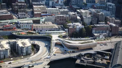
Seattle’s New Overlook Walk Offers Ample Park Space Near Pike Place Market
The elevated park and event space replaces part of the demolished Alaskan Way Viaduct, connecting the city’s famous Pike Place Market to the waterfront.

Alabama: Trump Terminates Settlements for Black Communities Harmed By Raw Sewage
Trump deemed the landmark civil rights agreement “illegal DEI and environmental justice policy.”

Planetizen Federal Action Tracker
A weekly monitor of how Trump’s orders and actions are impacting planners and planning in America.

The 120 Year Old Tiny Home Villages That Sheltered San Francisco’s Earthquake Refugees
More than a century ago, San Francisco mobilized to house thousands of residents displaced by the 1906 earthquake. Could their strategy offer a model for the present?

Ken Jennings Launches Transit Web Series
The Jeopardy champ wants you to ride public transit.

BLM To Rescind Public Lands Rule
The change will downgrade conservation, once again putting federal land at risk for mining and other extractive uses.

Indy Neighborhood Group Builds Temporary Multi-Use Path
Community members, aided in part by funding from the city, repurposed a vehicle lane to create a protected bike and pedestrian path for the summer season.
Urban Design for Planners 1: Software Tools
This six-course series explores essential urban design concepts using open source software and equips planners with the tools they need to participate fully in the urban design process.
Planning for Universal Design
Learn the tools for implementing Universal Design in planning regulations.
Clanton & Associates, Inc.
Jessamine County Fiscal Court
Institute for Housing and Urban Development Studies (IHS)
City of Grandview
Harvard GSD Executive Education
Toledo-Lucas County Plan Commissions
Salt Lake City
NYU Wagner Graduate School of Public Service