


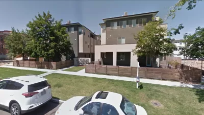
Two new classifications of land in Denver -- areas of change and areas of stability -- are moving the city's redevelopment and densification plans forward.
"The City Council's decision early Tuesday to rezone large swaths of West Highland and Sloan's Lake, limiting development to single-family homes, reflects the council's commitment to Blueprint Denver, the city's land-use and transportation road map."
"Blueprint Denver, adopted in March 2002, divides the city into two planning categories: areas of stability and areas of change."
"'It's not an anti-car thing,' said Peter Park, manager of Community Planning and Development. 'It's just that we needed to have a better balance of how we move about because, as we grow, as we 'densify', there is no way that we're going to grow and accommodate the expected growth and population and assume everyone is going to drive."
"'Because, if we do that, we don't have the road capacity for all the cars, and it wouldn't be a responsible way of building anyway.'"
FULL STORY: Zoning changes sharpen Denver's development goals


Denver Pauses Multifamily Development in Westside Neighborhoods Amidst Gentrification Concerns
City officials say the pause on permits for redevelopment projects aims to stop the displacement of long-term residents.
Denver Bans 'Slot Homes,' But Not Before They Changed Neighborhoods
Aerial photos show just how completely some areas of the city were transformed before the building typology was eliminated earlier this week.

Lawsuit Aims to Stop NYC’s ‘City of Yes’ Zoning Reforms
A lawsuit brought by local lawmakers and community groups claims the plan failed to conduct a comprehensive environmental review.

Alabama: Trump Terminates Settlements for Black Communities Harmed By Raw Sewage
Trump deemed the landmark civil rights agreement “illegal DEI and environmental justice policy.”

Planetizen Federal Action Tracker
A weekly monitor of how Trump’s orders and actions are impacting planners and planning in America.

The 120 Year Old Tiny Home Villages That Sheltered San Francisco’s Earthquake Refugees
More than a century ago, San Francisco mobilized to house thousands of residents displaced by the 1906 earthquake. Could their strategy offer a model for the present?

Ken Jennings Launches Transit Web Series
The Jeopardy champ wants you to ride public transit.

BLM To Rescind Public Lands Rule
The change will downgrade conservation, once again putting federal land at risk for mining and other extractive uses.

Indy Neighborhood Group Builds Temporary Multi-Use Path
Community members, aided in part by funding from the city, repurposed a vehicle lane to create a protected bike and pedestrian path for the summer season.
Urban Design for Planners 1: Software Tools
This six-course series explores essential urban design concepts using open source software and equips planners with the tools they need to participate fully in the urban design process.
Planning for Universal Design
Learn the tools for implementing Universal Design in planning regulations.
Clanton & Associates, Inc.
Jessamine County Fiscal Court
Institute for Housing and Urban Development Studies (IHS)
City of Grandview
Harvard GSD Executive Education
Toledo-Lucas County Plan Commissions
Salt Lake City
NYU Wagner Graduate School of Public Service