


One-fourth of the state’s land falls within 100-year or 500-year floodplains.
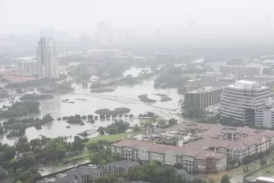
A draft statewide flood plan for Texas estimates that one in six of the state’s residents — or over 5 million people — live in a flood-prone area, reports Alejandra Martinez in The Texas Tribune.
The plan, developed by the Texas Water Development Board (TWDB), was a result of a 2019 law passed after Hurricane Harvey devastated the Houston area.
As Martinez explains, “The plan used existing flood data to create the maps that served as a baseline, but many state regions either didn't have flood maps, or used outdated maps. Local water managers filled the gaps with their knowledge and the TWDB contracted flood risk modeling data company Fathom to help.”
The TWDB recommends a variety of flood mitigation strategies, but Martinez notes that “the state doesn’t have a reliable source of revenue for flood projects unless state lawmakers approve additional funding each legislative session.”
The TWDB is also asking the state to implement an early warning system for flooding and provide technical assistance to small and rural communities. “Because money is limited for flood projects, the regional groups recommended that the state give counties the authority to collect drainage fees in unincorporated areas — currently only cities can charge such fees. The regional groups argue this would help counties self-finance flood mitigation and drainage projects outside of city limits.”
FULL STORY: Texas’ first-ever statewide flood plan estimates 5 million live in flood-prone areas


3D Modeling Aids in Predicting Hurricane Damage
Texas researchers are testing the tool in Galveston, where Hurricane Ike caused billions in damage in 2008.
New York Flood Control Plan Takes Lessons From the Dutch
The Netherlands has a long history of flood mitigation. U.S. cities, threatened by coastal flooding and erosion, are taking note.

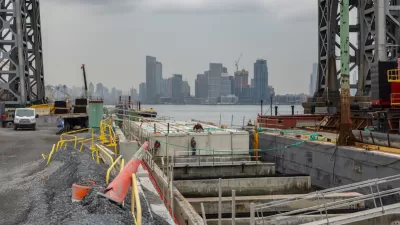
East River Floodgates Rising in NYC
A tour of new infrastructure designed to protect the city’s East Side from catastrophic flooding.

Alabama: Trump Terminates Settlements for Black Communities Harmed By Raw Sewage
Trump deemed the landmark civil rights agreement “illegal DEI and environmental justice policy.”

Planetizen Federal Action Tracker
A weekly monitor of how Trump’s orders and actions are impacting planners and planning in America.

The 120 Year Old Tiny Home Villages That Sheltered San Francisco’s Earthquake Refugees
More than a century ago, San Francisco mobilized to house thousands of residents displaced by the 1906 earthquake. Could their strategy offer a model for the present?

In Both Crashes and Crime, Public Transportation is Far Safer than Driving
Contrary to popular assumptions, public transportation has far lower crash and crime rates than automobile travel. For safer communities, improve and encourage transit travel.

Report: Zoning Reforms Should Complement Nashville’s Ambitious Transit Plan
Without reform, restrictive zoning codes will limit the impact of the city’s planned transit expansion and could exclude some of the residents who depend on transit the most.

Judge Orders Release of Frozen IRA, IIJA Funding
The decision is a victory for environmental groups who charged that freezing funds for critical infrastructure and disaster response programs caused “real and irreparable harm” to communities.
Urban Design for Planners 1: Software Tools
This six-course series explores essential urban design concepts using open source software and equips planners with the tools they need to participate fully in the urban design process.
Planning for Universal Design
Learn the tools for implementing Universal Design in planning regulations.
Clanton & Associates, Inc.
Jessamine County Fiscal Court
Institute for Housing and Urban Development Studies (IHS)
City of Grandview
Harvard GSD Executive Education
Toledo-Lucas County Plan Commissions
Salt Lake City
NYU Wagner Graduate School of Public Service