


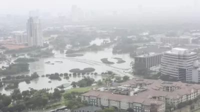
Texas researchers are testing the tool in Galveston, where Hurricane Ike caused billions in damage in 2008.

Researchers in Texas are testing out 3D modeling technology to predict potential hurricane damage and assess the effectiveness of proposed mitigation measures, reports Alyson Chapman in Route Fifty. The team used residential buildings to map out potential flood risk and understand the potential impacts of a flood mitigation project, the ‘Ike Dike,’ designed to shield Galveston from future storms.
An advantage of 3D visualization over other damage modeling methods is that it allows researchers to model specific buildings, accounting for basements, back entrances, and windows. By identifying a residential building’s first-floor elevation level, researchers can predict the physical and financial damage that a hurricane will cause to the specific building.
Expanding the tool to commercial and public buildings can help local officials develop hurricane preparedness plans. Additionally, “As real-time weather forecasts are implemented into the models, researchers may be able to determine when evacuation is necessary and use this data to alert residents.”
FULL STORY: 3D visualization predicts hurricane damage before it happens

Texas Flood Plan Shows One in Six Residents Live With Flood Risk
One-fourth of the state’s land falls within 100-year or 500-year floodplains.
New York Flood Control Plan Takes Lessons From the Dutch
The Netherlands has a long history of flood mitigation. U.S. cities, threatened by coastal flooding and erosion, are taking note.

East River Floodgates Rising in NYC
A tour of new infrastructure designed to protect the city’s East Side from catastrophic flooding.

Trump Administration Could Effectively End Housing Voucher Program
Federal officials are eyeing major cuts to the Section 8 program that helps millions of low-income households pay rent.

Planetizen Federal Action Tracker
A weekly monitor of how Trump’s orders and actions are impacting planners and planning in America.

Ken Jennings Launches Transit Web Series
The Jeopardy champ wants you to ride public transit.

Washington Legislature Passes Rent Increase Cap
A bill that caps rent increases at 7 percent plus inflation is headed to the governor’s desk.

From Planning to Action: How LA County Is Rethinking Climate Resilience
Chief Sustainability Officer Rita Kampalath outlines the County’s shift from planning to implementation in its climate resilience efforts, emphasizing cross-departmental coordination, updated recovery strategies, and the need for flexible funding.

New Mexico Aging Department Commits to Helping Seniors Age ‘In Place’ and ‘Autonomously’ in New Draft Plan
As New Mexico’s population of seniors continues to grow, the state’s aging department is proposing expanded initiatives to help seniors maintain their autonomy while also supporting family caregivers.
Urban Design for Planners 1: Software Tools
This six-course series explores essential urban design concepts using open source software and equips planners with the tools they need to participate fully in the urban design process.
Planning for Universal Design
Learn the tools for implementing Universal Design in planning regulations.
Heyer Gruel & Associates PA
Ada County Highway District
Institute for Housing and Urban Development Studies (IHS)
City of Grandview
Harvard GSD Executive Education
Toledo-Lucas County Plan Commissions
Salt Lake City
NYU Wagner Graduate School of Public Service