


Where do the most traffic deaths happen?
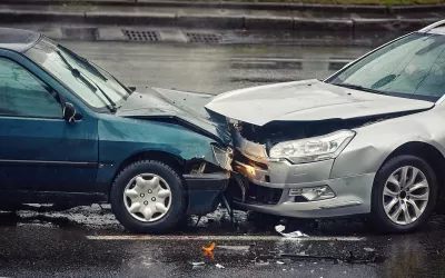
An analysis of National Highway Traffic Safety Administration data collected over 18 years reveals trends in where fatal car crashes occur. About a quarter of deadly crashes happen in intersections and are concentrated in under 900 “deadly intersections” where three or more fatal crashes have occurred.
According to an article in Arizona’s Family, “Across all intersections, main arteries — higher-speed road classes including interstates, U.S. and state highways, and county roads — are part of just over 65% of fatal crashes and 57% of deaths, either intersecting with each other or with local roadways.” Main arteries, with their higher speed limits, pose more risk: fatal crashes are more than twice as likely to happen at the intersection of two arteries.
At the state level, Florida “is #1 in fatal crashes at all intersections and at deadly intersections, and it has more than three times as many deadly intersections (257) as the next highest state, Arizona (82).”
FULL STORY: The deadliest intersections in America, according to the National Highway Traffic Safety Administration

Portland Traffic Deaths Surpass 2022 Number
This year, 69 people have died in traffic crashes in Portland, Oregon, nearly twice as many as in 2018, when the city began its Vision Zero program.

NHTSA: Traffic Fatalities Decline for Fifth Straight Quarter
Traffic deaths were 3.3 percent lower in the first half of 2023 than the same period last year, but not all states saw the same results.

Washington Road Safety Bills Fail to Advance
Several bills aimed at reducing traffic deaths fell by the wayside in the state legislature, despite the growing rate of road fatalities.

Alabama: Trump Terminates Settlements for Black Communities Harmed By Raw Sewage
Trump deemed the landmark civil rights agreement “illegal DEI and environmental justice policy.”

Planetizen Federal Action Tracker
A weekly monitor of how Trump’s orders and actions are impacting planners and planning in America.

Why Should We Subsidize Public Transportation?
Many public transit agencies face financial stress due to rising costs, declining fare revenue, and declining subsidies. Transit advocates must provide a strong business case for increasing public transit funding.

Understanding Road Diets
An explainer from Momentum highlights the advantages of reducing vehicle lanes in favor of more bike, transit, and pedestrian infrastructure.

New California Law Regulates Warehouse Pollution
A new law tightens building and emissions regulations for large distribution warehouses to mitigate air pollution and traffic in surrounding communities.

Phoenix Announces Opening Date for Light Rail Extension
The South Central extension will connect South Phoenix to downtown and other major hubs starting on June 7.
Urban Design for Planners 1: Software Tools
This six-course series explores essential urban design concepts using open source software and equips planners with the tools they need to participate fully in the urban design process.
Planning for Universal Design
Learn the tools for implementing Universal Design in planning regulations.
Caltrans
Smith Gee Studio
Institute for Housing and Urban Development Studies (IHS)
City of Grandview
Harvard GSD Executive Education
Toledo-Lucas County Plan Commissions
Salt Lake City
NYU Wagner Graduate School of Public Service