


The proposed Dorchester Greenway would create a new linear park above part of the Red Line subway.
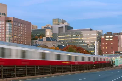
A proposed greenway would cap a 0.75-mile subterranean segment of Boston’s Red Line subway with a linear park, reports Daniel Roche in The Architect’s Newspaper. “With $300,000 in funding from the MassTrails program, a state initiative, and an additional $368,000 from the city of Boston; officials, community leaders, and designers are gearing up to build a new pathway for walkers and bikers, dubbed The Dorchester Greenway.”
According to Roche, “Today, the stretch between Fields Corner Station and Ashmont Station is below grade, topped by a derelict asphalt carpet. For years, community activists have sought to build a park on the land currently owned by the Massachusetts Bay Transportation Authority (MBTA).” Local advocates say the greenway would provide new public green space and stitch the neighborhood back together. Cap parks are becoming an increasingly popular way to utilize space above active or defunct freeways or subway lines, although some projects, like one in Denver, have triggered gentrification and displacement concerns.
FULL STORY: The Dorchester Greenway, a speculative linear park, may soon be built in Boston over the Red Line

I Help Plan Cap Parks; Here’s What Austin Can Learn from Other Cities
How freeway capping projects can literally and metaphorically bridge urban divides.
USDOT Denies Portland Freeway Expansion Grant
The agency declined the Oregon Department of Transportation’s request for $750 million to fund the I-5 Rose Quarter Improvement Project.
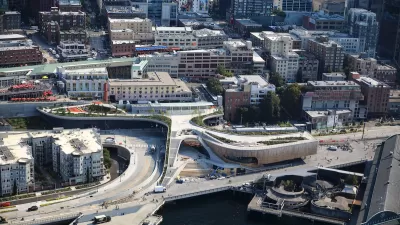
Seattle’s New Overlook Walk Offers Ample Park Space Near Pike Place Market
The elevated park and event space replaces part of the demolished Alaskan Way Viaduct, connecting the city’s famous Pike Place Market to the waterfront.

Alabama: Trump Terminates Settlements for Black Communities Harmed By Raw Sewage
Trump deemed the landmark civil rights agreement “illegal DEI and environmental justice policy.”

Planetizen Federal Action Tracker
A weekly monitor of how Trump’s orders and actions are impacting planners and planning in America.

The 120 Year Old Tiny Home Villages That Sheltered San Francisco’s Earthquake Refugees
More than a century ago, San Francisco mobilized to house thousands of residents displaced by the 1906 earthquake. Could their strategy offer a model for the present?

Ken Jennings Launches Transit Web Series
The Jeopardy champ wants you to ride public transit.

BLM To Rescind Public Lands Rule
The change will downgrade conservation, once again putting federal land at risk for mining and other extractive uses.

Indy Neighborhood Group Builds Temporary Multi-Use Path
Community members, aided in part by funding from the city, repurposed a vehicle lane to create a protected bike and pedestrian path for the summer season.
Urban Design for Planners 1: Software Tools
This six-course series explores essential urban design concepts using open source software and equips planners with the tools they need to participate fully in the urban design process.
Planning for Universal Design
Learn the tools for implementing Universal Design in planning regulations.
Clanton & Associates, Inc.
Jessamine County Fiscal Court
Institute for Housing and Urban Development Studies (IHS)
City of Grandview
Harvard GSD Executive Education
Toledo-Lucas County Plan Commissions
Salt Lake City
NYU Wagner Graduate School of Public Service