


A new feature highlights routes that use the least gas to help users make the most fuel-efficient driving decisions.
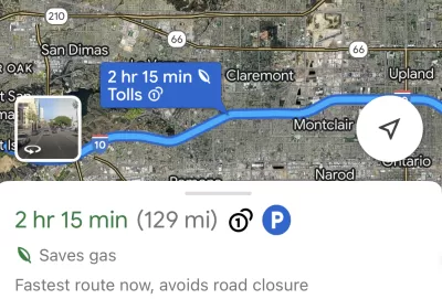
Have you noticed the “Saves gas” option in your Google Maps directions? Plug in a destination and you’ll likely receive several options, one of which will be labeled as the most fuel-efficient one.
According to an article by Justine Calma in The Verge, “Google uses a machine learning model to predict which route is the most fuel- or energy-efficient and recommends it to Maps users. If the most fuel-efficient route is also the fastest, Google Maps will default to that option.” The company says drivers have used these suggested routes to save roughly 1.2 million metric tons of carbon dioxide emissions since it launched the tool in 2021.
Users can also provide additional information, such as whether they drive an electric car, to get more accurate results. “To be sure, taking public transit, biking, or walking are still more sustainable alternatives, and Google says it’s working to make Maps easier to use outside of driving.”
Calma points out that “Google produces exponentially more pollution than any household, of course. Its carbon footprint added up to more than 10.18 million metric tons of CO2 emitted in 2022, roughly equivalent to pollution from more than 25 gas-fired power plants in a year.”
FULL STORY: People are using Google Maps to cut down tailpipe pollution


Toyota’s Hybrid Popularity Outpaces Production Worldwide
Soaring global demand for Toyota's hybrid vehicles is straining the automaker’s supply chain, leading to widespread delays as component shortages and limited production capacity challenge its ability to keep up.
Report: 14 States Increased Per-Capita Carbon Emissions
Many of the states on the list are red-leaning states that fought against federal environmental reporting regulations.
Report: Some Rural States Ahead of More Urbanized Ones in Reducing Transportation Emissions
This is a largely unintended consequence of states with lower populations and resources focusing on repairing existing roads and infrastructure rather than expanding and building new roads.

Alabama: Trump Terminates Settlements for Black Communities Harmed By Raw Sewage
Trump deemed the landmark civil rights agreement “illegal DEI and environmental justice policy.”

Planetizen Federal Action Tracker
A weekly monitor of how Trump’s orders and actions are impacting planners and planning in America.

The 120 Year Old Tiny Home Villages That Sheltered San Francisco’s Earthquake Refugees
More than a century ago, San Francisco mobilized to house thousands of residents displaced by the 1906 earthquake. Could their strategy offer a model for the present?

In Both Crashes and Crime, Public Transportation is Far Safer than Driving
Contrary to popular assumptions, public transportation has far lower crash and crime rates than automobile travel. For safer communities, improve and encourage transit travel.

Report: Zoning Reforms Should Complement Nashville’s Ambitious Transit Plan
Without reform, restrictive zoning codes will limit the impact of the city’s planned transit expansion and could exclude some of the residents who depend on transit the most.

Judge Orders Release of Frozen IRA, IIJA Funding
The decision is a victory for environmental groups who charged that freezing funds for critical infrastructure and disaster response programs caused “real and irreparable harm” to communities.
Urban Design for Planners 1: Software Tools
This six-course series explores essential urban design concepts using open source software and equips planners with the tools they need to participate fully in the urban design process.
Planning for Universal Design
Learn the tools for implementing Universal Design in planning regulations.
Clanton & Associates, Inc.
Jessamine County Fiscal Court
Institute for Housing and Urban Development Studies (IHS)
City of Grandview
Harvard GSD Executive Education
Toledo-Lucas County Plan Commissions
Salt Lake City
NYU Wagner Graduate School of Public Service