


The population center of Harris County is now outside central Houston, a shift that occurred over the last two decades as the region's suburbs blossomed.
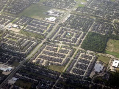
For the first time in the city's history, Harris County's population center has moved away from the downtown Houston loop, signaling that the decentralization characteristic to the sprawling metropolis has finally shifted the center of gravity of the region itself. As Matt Dulin writes, "The center of Harris County now falls right along West 34th Street near Ella Boulevard on the edge of the Oak Forest neighborhood—a suburb from another era of expansion, making it an appropriate nod to the city’s past and the region’s future."
Houston's population has grown by around 40 percent since the turn of the 21st century, with growth concentrated in suburbs in the northwestern part of Harris County. According to Dulin, the region has seen the most suburban and exurban growth of the top five metropolitan statistical areas in the U.S. "To put it another way: The Houston MSA’s population outside Houston city limits grew 7 times faster than the city itself."
With plenty of available land and high demand for planned suburban communities, experts expect that outward development in the Houston region will continue. But Dulin notes that the central city has experienced its own redevelopment, and the rising values of homes in neighborhoods like Oak Forest indicate a strong interest in living near downtown—if the city can provide the amenities that make urban neighborhoods safe and livable.
This year, developers are expected to break ground on a slew of major projects in both central and suburban Houston, including the new headquarters of Hewlett Packard Enterprise and a 28-story downtown office tower.
FULL STORY: After 20 years, the center of Harris County's population has moved outside the Loop


First Model Homes Revealed in Disney-Built Community
Disney’s Cotino, in the Southern California desert, is the first of the company’s ‘Storybook Living’ developments.

Promoting Infill Development for a Denser Houston
An advocacy group is calling for ‘sustainable, vertical’ mixed-use urbanism in the famously sprawling city.

The Changing Shape of American Suburbs
Housing costs and availability are pushing more American households, including young families, to suburbs and exurbs — and they’re demanding changes.

Alabama: Trump Terminates Settlements for Black Communities Harmed By Raw Sewage
Trump deemed the landmark civil rights agreement “illegal DEI and environmental justice policy.”

Planetizen Federal Action Tracker
A weekly monitor of how Trump’s orders and actions are impacting planners and planning in America.

The 120 Year Old Tiny Home Villages That Sheltered San Francisco’s Earthquake Refugees
More than a century ago, San Francisco mobilized to house thousands of residents displaced by the 1906 earthquake. Could their strategy offer a model for the present?

In Both Crashes and Crime, Public Transportation is Far Safer than Driving
Contrary to popular assumptions, public transportation has far lower crash and crime rates than automobile travel. For safer communities, improve and encourage transit travel.

Report: Zoning Reforms Should Complement Nashville’s Ambitious Transit Plan
Without reform, restrictive zoning codes will limit the impact of the city’s planned transit expansion and could exclude some of the residents who depend on transit the most.

Judge Orders Release of Frozen IRA, IIJA Funding
The decision is a victory for environmental groups who charged that freezing funds for critical infrastructure and disaster response programs caused “real and irreparable harm” to communities.
Urban Design for Planners 1: Software Tools
This six-course series explores essential urban design concepts using open source software and equips planners with the tools they need to participate fully in the urban design process.
Planning for Universal Design
Learn the tools for implementing Universal Design in planning regulations.
Clanton & Associates, Inc.
Jessamine County Fiscal Court
Institute for Housing and Urban Development Studies (IHS)
City of Grandview
Harvard GSD Executive Education
Toledo-Lucas County Plan Commissions
Salt Lake City
NYU Wagner Graduate School of Public Service