


Plans for the area include thousands of new housing units, public parks, and improved bike and pedestrian infrastructure.

As the Crenshaw rail line reaches completion, the city of Inglewood is considering changes to its zoning regulations "which would permit the construction of new homes, offices, and retail near passenger rail stops on Metro's Crenshaw/LAX and C Lines," reports Steven Sharp in Urbanize Los Angeles. The Westchester/Veterans and Crenshaw/Imperial TOD (Transit Oriented Development) Plans "would impact land use regulations for roughly 650 acres of land at Inglewood's northwest corner adjacent to the Westchester neighborhood and at its southern border with the City of Hawthorne," adding up to 4,090 new homes, 705,000 square feet of commercial space, and 5,684 new jobs. The plans also include new cycletracks, improved pedestrian mobility, and new public parks.
Local leaders hope the construction of the new Crenshaw Line, which was originally scheduled to open in 2019, will provide new transit options for workers in the area and boost economic activity in the area. "The City has already adopted new zoning for its Downtown and Fairview Heights neighborhoods, which also sit along the transit line's route."
"Implementation of the visions detailed in the TOD plans will require multiple discretionary approvals, both by the city of Inglewood and other entities, such as the city of Hawthorne and Caltrans. A draft environmental impact report is now being circulated for review."
FULL STORY: Inglewood considers new zoning near Crenshaw/LAX and C Line stations


NoHo and SoHo Rezoning Controversies, Amplified
One of the big questions of planning is up for debate with a proposed rezoning in the SoHo and NoHo neighborhoods of New York City: Can upzoning be an effective tool for affordability?
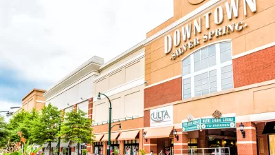
Silver Spring Downtown Plan Expanding to Make Room for the Missing Middle
Planners are hoping that by expanding the boundaries of the Silver Spring Downtown Plan in Montgomery County, Maryland, new opportunities for missing middle housing will create new opportunities for housing affordability.
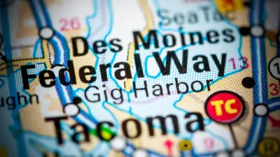
A Transit and Land Use Planning Shift in Federal Way, Washington
Federal funding for Sound Transit's Federal Way Link extension and a new transit-oriented land use plan are changing the future of Federal Way.

Alabama: Trump Terminates Settlements for Black Communities Harmed By Raw Sewage
Trump deemed the landmark civil rights agreement “illegal DEI and environmental justice policy.”

Planetizen Federal Action Tracker
A weekly monitor of how Trump’s orders and actions are impacting planners and planning in America.

The 120 Year Old Tiny Home Villages That Sheltered San Francisco’s Earthquake Refugees
More than a century ago, San Francisco mobilized to house thousands of residents displaced by the 1906 earthquake. Could their strategy offer a model for the present?

Ken Jennings Launches Transit Web Series
The Jeopardy champ wants you to ride public transit.

BLM To Rescind Public Lands Rule
The change will downgrade conservation, once again putting federal land at risk for mining and other extractive uses.

Indy Neighborhood Group Builds Temporary Multi-Use Path
Community members, aided in part by funding from the city, repurposed a vehicle lane to create a protected bike and pedestrian path for the summer season.
Urban Design for Planners 1: Software Tools
This six-course series explores essential urban design concepts using open source software and equips planners with the tools they need to participate fully in the urban design process.
Planning for Universal Design
Learn the tools for implementing Universal Design in planning regulations.
Clanton & Associates, Inc.
Jessamine County Fiscal Court
Institute for Housing and Urban Development Studies (IHS)
City of Grandview
Harvard GSD Executive Education
Toledo-Lucas County Plan Commissions
Salt Lake City
NYU Wagner Graduate School of Public Service