


An Atlanta case study.

APD Urban Planning & Management (APD-U), an Atlanta-based planning consultant, recently completed the Atlanta Opportunity Zone Displacement Risk Analysis, GIS maps with data to illustrate the varying levels of displacement risk facing homeowners, renters, and businesses.
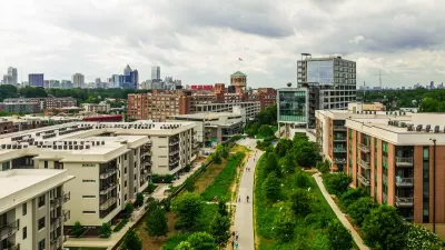
Oscar Perry Abello shares news of the new analysis, providing background on the genesis of APD-U's analysis and the Opportunity Zone program. Among the findings of the analysis: the West End neighborhood in Atlanta is home to a high proportion of households and businesses vulnerable to displacement.
In Atlanta’s West End, APD-U’s analysis shows 1,161 renter households, 743 of whom are at Level 1 risk of displacement, the highest level. Meanwhile out of 251 homeowners, just 50 are at Level 1 risk of displacement.
Out of 112 businesses in the West End census tract, 78 are at Level 1 risk of displacement.
The Urban Institute released their own analysis of equity outcomes from the Opportunity Zone program so far.
FULL STORY: Displacement Risk in Atlanta’s Opportunity Zones, Mapped

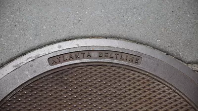
Beltline Surpasses Annual Affordable Housing Goal
The Atlanta Beltline agency is actively working to prevent the displacement of longtime residents along the trail system, where property values are rising rapidly.

How To Prevent ‘Green Gentrification’: Lessons from the BeltLine
For one author, the key is focusing on affordable housing from the start.
The Atlanta BeltLine Wants to Prevent Displacement of Longtime Residents. Is it Too Late?
A program to pay property-tax increases of nearby homeowners is welcome, but "about ten years too late," one advocate says.

Alabama: Trump Terminates Settlements for Black Communities Harmed By Raw Sewage
Trump deemed the landmark civil rights agreement “illegal DEI and environmental justice policy.”

Planetizen Federal Action Tracker
A weekly monitor of how Trump’s orders and actions are impacting planners and planning in America.

The 120 Year Old Tiny Home Villages That Sheltered San Francisco’s Earthquake Refugees
More than a century ago, San Francisco mobilized to house thousands of residents displaced by the 1906 earthquake. Could their strategy offer a model for the present?

Ken Jennings Launches Transit Web Series
The Jeopardy champ wants you to ride public transit.

BLM To Rescind Public Lands Rule
The change will downgrade conservation, once again putting federal land at risk for mining and other extractive uses.

Indy Neighborhood Group Builds Temporary Multi-Use Path
Community members, aided in part by funding from the city, repurposed a vehicle lane to create a protected bike and pedestrian path for the summer season.
Urban Design for Planners 1: Software Tools
This six-course series explores essential urban design concepts using open source software and equips planners with the tools they need to participate fully in the urban design process.
Planning for Universal Design
Learn the tools for implementing Universal Design in planning regulations.
Clanton & Associates, Inc.
Jessamine County Fiscal Court
Institute for Housing and Urban Development Studies (IHS)
City of Grandview
Harvard GSD Executive Education
Toledo-Lucas County Plan Commissions
Salt Lake City
NYU Wagner Graduate School of Public Service