


The 220-mile route would connect the two cities and could potentially boost the economies of communities along the stretch.
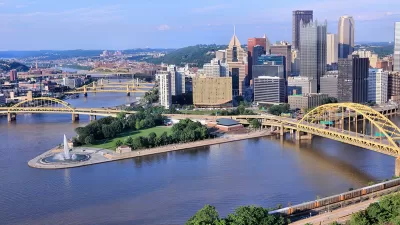
"Connecting Pittsburgh to Cleveland by trail could be very good for both metro areas and people who live in them as well as elsewhere around the region and beyond. And not just for their legs and lungs and moods, but also for the health of local economies and communities," writes Bob Batz Jr.
The Rails-to-Trails Conservancy recently released a feasibility study for this corridor, part of a 1,500-mile route through New York, Pennsylvania, Ohio, and West Virginia. The stretch between Pittsburgh and Cleveland would also connect to other trail systems in the region.
Proponents say that the project would drive community and economic development, including tourism and residential developments near the trail.
The trail would be a major undertaking, and various gaps still exist along the route. "The study gives specific recommendations on how local groups can complete the missing pieces and estimates the millions of dollars that [it] will cost to do and to maintain," says Batz.
FULL STORY: Cleveland-to-Pittsburgh would be a big link in cross-country rail trail

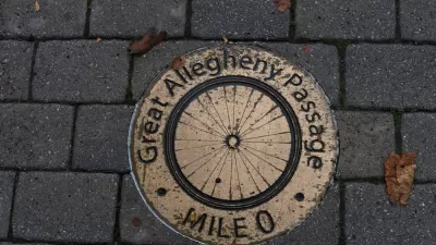
Measuring the Economic Impact of the Great Allegheny Passage
Small communities once dependent on coal, coke, paper, lumber, and manufacturing now have a 150-mile bike and pedestrian path contributing to the local economy.
Economic Recovery in Legacy Cities
Americans living in legacy cities face a unique set of challenges and opportunities in recovering from the COVID-19 pandemic. Several local, state, and federal support strategies could aid these cities in recouping losses.
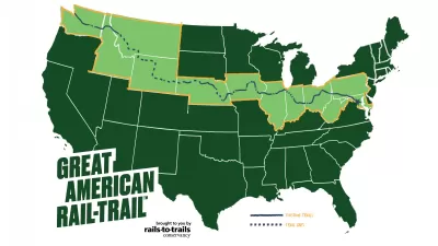
Revealed: A Plan to Build a Continuous Bike Trail Across the United States
Motorists have been able to drive across the country for more than a century. People on bikes will get their day soon, too.

Alabama: Trump Terminates Settlements for Black Communities Harmed By Raw Sewage
Trump deemed the landmark civil rights agreement “illegal DEI and environmental justice policy.”

Planetizen Federal Action Tracker
A weekly monitor of how Trump’s orders and actions are impacting planners and planning in America.

The 120 Year Old Tiny Home Villages That Sheltered San Francisco’s Earthquake Refugees
More than a century ago, San Francisco mobilized to house thousands of residents displaced by the 1906 earthquake. Could their strategy offer a model for the present?

Ken Jennings Launches Transit Web Series
The Jeopardy champ wants you to ride public transit.

BLM To Rescind Public Lands Rule
The change will downgrade conservation, once again putting federal land at risk for mining and other extractive uses.

Indy Neighborhood Group Builds Temporary Multi-Use Path
Community members, aided in part by funding from the city, repurposed a vehicle lane to create a protected bike and pedestrian path for the summer season.
Urban Design for Planners 1: Software Tools
This six-course series explores essential urban design concepts using open source software and equips planners with the tools they need to participate fully in the urban design process.
Planning for Universal Design
Learn the tools for implementing Universal Design in planning regulations.
Clanton & Associates, Inc.
Jessamine County Fiscal Court
Institute for Housing and Urban Development Studies (IHS)
City of Grandview
Harvard GSD Executive Education
Toledo-Lucas County Plan Commissions
Salt Lake City
NYU Wagner Graduate School of Public Service