


Unlike for land use regulations, state law doesn't require Caltrans to switch from Level of Service to Vehicle Miles Traveled in measuring the environmental impact of projects. The state department of transportation is making the change anyway.
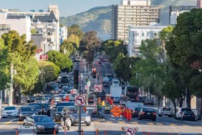
"Caltrans hosted a webinar recently to discuss changes it will be adopting soon in the way the department measures, analyzes, and mitigates for the environmental impacts of transportation projects on the state highway system," reports Melanie Curry.
The webinar comes with the acknowledgment that Caltrans' "current practices have not solved urban congestion and instead have led to more driving, more emissions, and unsafe conditions for people who don’t drive," according to Curry.
Astute obervers of California planning law will recall that the state passed SB 743 in 2013, which required land use and transportation projects in the state to switch from Level of Service (LOS) to Vehicle Miles Traveled (VMT) to measure environmental impact. The law, however, "gave transportation agencies some leeway on transportation projects, saying they 'could choose the most appropriate' way to measure environmental impacts," explains Cuirry.
Fast forward to the recent news about Caltrans, and we have here the the state department of transportation choosing VMT as the most appropriate way to measure environmental impacts.
Caltrans is still ironing out the details of how it will make the change, but Curry has plenty of information to share about how the change will change planning and approvals in the state.
FULL STORY: Caltrans Will Account for New Vehicle Miles Produced by its Transportation Projects


New Rule on Environmental Impacts of Driving, Long Awaited, Goes Into Effect Today
At long last, California law will consider the amount of driving, rather than vehicle delay, when evaluating the environmental impacts of new developments. This is a more common-sense approximation of their environmental impacts.

CEQA Reform: The Public Health Community Is Cheering Too
An op-ed describing the public health benefits of CEQA reform and urging California's leaders to finalize the end of "Level of Service" as a measure of project impacts.
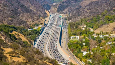
Report: Bike Lanes Can't Make up for New Roads
If California wants to meet its climate goals, the state must stop funding its myriad road construction and expansion projects.

Alabama: Trump Terminates Settlements for Black Communities Harmed By Raw Sewage
Trump deemed the landmark civil rights agreement “illegal DEI and environmental justice policy.”

Planetizen Federal Action Tracker
A weekly monitor of how Trump’s orders and actions are impacting planners and planning in America.

The 120 Year Old Tiny Home Villages That Sheltered San Francisco’s Earthquake Refugees
More than a century ago, San Francisco mobilized to house thousands of residents displaced by the 1906 earthquake. Could their strategy offer a model for the present?

Ken Jennings Launches Transit Web Series
The Jeopardy champ wants you to ride public transit.

BLM To Rescind Public Lands Rule
The change will downgrade conservation, once again putting federal land at risk for mining and other extractive uses.

Indy Neighborhood Group Builds Temporary Multi-Use Path
Community members, aided in part by funding from the city, repurposed a vehicle lane to create a protected bike and pedestrian path for the summer season.
Urban Design for Planners 1: Software Tools
This six-course series explores essential urban design concepts using open source software and equips planners with the tools they need to participate fully in the urban design process.
Planning for Universal Design
Learn the tools for implementing Universal Design in planning regulations.
Clanton & Associates, Inc.
Jessamine County Fiscal Court
Institute for Housing and Urban Development Studies (IHS)
City of Grandview
Harvard GSD Executive Education
Toledo-Lucas County Plan Commissions
Salt Lake City
NYU Wagner Graduate School of Public Service