


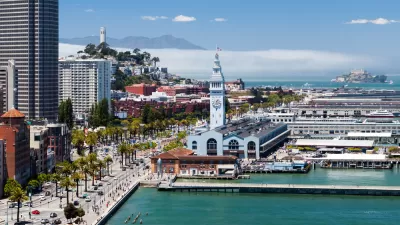
The Port of San Francisco is wrapping up a three-year planning process to chart the ongoing transformation of the city's waterfront.

John King shares news of a plan released earlier this month that sets a path for the future of 7.5 miles of waterfront property owned by the port of San Francisco, stretching from Fisherman’s Wharf to Heron’s Head Park in the Bayview. "Along the way are such popular destinations as the Ferry Building and the Giants’ ballpark along the Embarcadero, but also the dormant ship repair dry dock at Pier 70 and a large recycling plant at Pier 96," explains King of the significance of this part of town.
The new plan follows on previous plan, written over two decades ago, that set in motion the revival of large portions of the waterfront. "But stubborn challenges remain," according to King, like a steady stream of development controversies and the need to prepare for sea-level rise. In response to the controversies, the plan sets goals of "Partnering for Success" and involving the community in decisions and whatever new amenities emerge from the plan.
Among the other specific recommendations of the report, citied by King in the article:
- Converting the paved area behind the Ferry Building into a "true piazza."
- Offering piers 3-32 to private development.
- Reopening the ship repair facilities at Pier 70 to attract high-paying jobs to the area.
King, who provides a lot more detail on the new plan in the source article, reported extensively on the outcomes of the previous plan in 2014 when the Port of San Francisco was ramping up to begin the process that produced the new plan.
FULL STORY: Plan unveiled for San Francisco’s waterfront — includes Ferry Building ‘piazza’

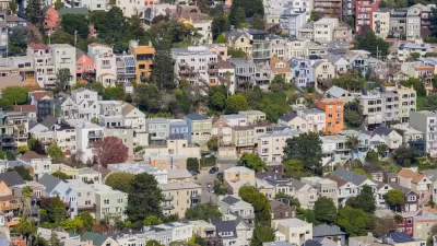
San Francisco Plans for 82,000 New Housing Units
California housing regulators have granted preliminary approval for the city of San Francisco’s housing element as mandated by the state’s Regional Housing Needs Allocation process.
San Francisco Returns $15 Million Federal Grant for Market Street Improvements
San Francisco was awarded a federal grant in 2018 that it was forced to return in 2022 because it couldn't start construction by 2025.
Port of San Francisco, Army Corps of Engineers Planning for Rising Bay Waters
A massive climate adaptation planning effort is underway for the docks (and seawalls and landfill) of the San Francisco Bay.

Alabama: Trump Terminates Settlements for Black Communities Harmed By Raw Sewage
Trump deemed the landmark civil rights agreement “illegal DEI and environmental justice policy.”

Planetizen Federal Action Tracker
A weekly monitor of how Trump’s orders and actions are impacting planners and planning in America.

The 120 Year Old Tiny Home Villages That Sheltered San Francisco’s Earthquake Refugees
More than a century ago, San Francisco mobilized to house thousands of residents displaced by the 1906 earthquake. Could their strategy offer a model for the present?

Ken Jennings Launches Transit Web Series
The Jeopardy champ wants you to ride public transit.

BLM To Rescind Public Lands Rule
The change will downgrade conservation, once again putting federal land at risk for mining and other extractive uses.

Indy Neighborhood Group Builds Temporary Multi-Use Path
Community members, aided in part by funding from the city, repurposed a vehicle lane to create a protected bike and pedestrian path for the summer season.
Urban Design for Planners 1: Software Tools
This six-course series explores essential urban design concepts using open source software and equips planners with the tools they need to participate fully in the urban design process.
Planning for Universal Design
Learn the tools for implementing Universal Design in planning regulations.
Clanton & Associates, Inc.
Jessamine County Fiscal Court
Institute for Housing and Urban Development Studies (IHS)
City of Grandview
Harvard GSD Executive Education
Toledo-Lucas County Plan Commissions
Salt Lake City
NYU Wagner Graduate School of Public Service