


Mahbubur Meenar of Rowan University writes about a recent article he co-authored in the Journal of Planning Education and Research

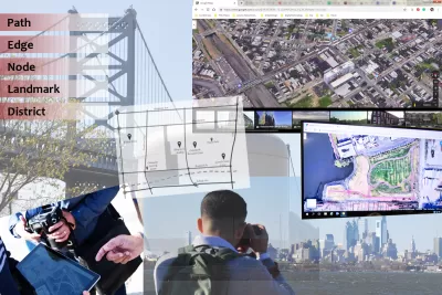
Kevin Lynch—whose 100th birthday we celebrated in 2018—introduced the idea of a city’s imageability, or the quality of the city elements that trigger lucid images in an observer. Lynch devised his mental mapping techniques prior to the invention of digital technologies (e.g., the Internet, smart phones, GPS) or virtual mapping environments (e.g., Google Map/Earth/Street View). Though planning practitioners, educators, and scholars find Lynchian techniques useful in understanding city images for creating memorable and legible places for residents, they have mostly explored cities’ imageability through field observations. As virtual mapping technologies continue to advance and become increasingly available, urban planners can explore city elements at various levels, scales, and times without a site visit. There is a need then to understand technology’s role in assisting planners conduct city imageability analysis. How can we create mental images of city elements (e.g., paths, edges, districts, nodes, and landmarks) by using virtual versus physical environments? What are the strengths and weaknesses of each method? Based on a three-week long study in 2016 and a repeat study in 2017, we have explored these questions in our recent article in the Journal of Planning Education & Research.
We analyzed 68 mental maps created by 34 participants who were upper-level undergraduate students in planning and related social-science programs with an age group ranging from 22 to 33 years. Each participant created one mental map of a neighborhood based on virtual exploration and one mental map of another neighborhood based on physical environment exploration through fieldwork. Each neighborhood was analyzed by two participants separately using two types of methods. Finally, they compared their maps and initial reports focusing on each neighborhood they explored in a final report.
We calculated the percentages of agreement versus disagreement on the perception of city elements between two participants working on the same neighborhood but using two different methods. While the majority of the participants agreed on the locations of paths, nodes, and districts in both years, the majority of them disagreed about edges and landmarks. Considering comments (reports) as the unit of analysis, we used qualitative content analysis to identify five key factors that might be responsible for any discrepancies in the findings due to the use of different methods: (1) Scale: Participants who viewed neighborhoods virtually often underestimated the size, presence, or importance of paths, edges, or landmarks; (2) Eye-level: Using bird's eye view and fly-through capability of virtual environments, participants were able to identify city elements obstructed or hidden at the eye-level; (3) Details: Virtual exploration generally provided fewer details (e.g., architectural style, lack of access due to gates and locks) than the physical environment exploration; (4) Accuracy and timeliness: The date/time of recorded features in areas under significant transition resulted in substantially different interpretation of neighborhoods; and (5) Sensory/movement: The lack of movement and limited sensory experiences (e.g., sound, smell) in virtual exploration led to limited observations.
We identified several strengths and weaknesses of both methods. Virtual environment exploration offers the following strengths: it facilitates general understanding of the area, provides access to other web-based resources, can be resource efficient, allows exploration from anywhere at anytime, and can view old images. This method, however, may not capture qualitative aspects of an area or may not capture as much details as the other method. Physical environment exploration helps with comprehensive exploration and capturing the sense of place. As it is conducted in real-time it may be more accurate. On the other hand, this method can be inefficient or weak in capturing the overall picture of an area and can be very resource intensive.
Our imagined city is not the same as the actual city. Planners doing imageability analysis need to document the perceived environment and not necessarily the reality in its full shape and complexity. In this article, we have explained several implications of our research for planning practice and pedagogy: site exploration, resource management, data accessibility, and perceived versus objective environments. Based on our study, virtual exploration can help planners conduct field observations for Lynchian analysis when dealing with resource limitations (e.g., time, budget, staff). Combining virtual environment observation with traditional field observation of physical environment can advance urban imageability exploration which may eventually help planners design more legible and memorable places.
Full Article Open Access Until June 17, 2019
Dr. Mahbubur Meenar is an Assistant Professor of Planning in the Department of Geography, Planning, and Sustainability at Rowan University.
Nader Afzalan, Ph.D., is a Senior Planner and Air Pollution Specialist at the California Air Resources Board.
Amir Hajrasouliha, Ph.D., is an Assistant Professor at California Polytechnic State University


Like Waze, But for Bikes
The mobile app LaneSpotter, described as a navigation app like Waze but for cyclists, has announced eight cities as the location for a pilot launch.
Google Maps Update Opens New Access to Mobility and Culture
Google Maps and other navigation and mapping apps have done a lot to inspire and educate people to make the most of their surroundings. New changes to the Google Maps app will add new functionality for those purposes.
Does the Evolution of Smartphones Come at the Expense of 'Spatial Thinking'?
Are smartphones supplementing the capacity of humans to think spatially, such that future generations might lose fundamental cognitive abilities?

Alabama: Trump Terminates Settlements for Black Communities Harmed By Raw Sewage
Trump deemed the landmark civil rights agreement “illegal DEI and environmental justice policy.”

Planetizen Federal Action Tracker
A weekly monitor of how Trump’s orders and actions are impacting planners and planning in America.

The 120 Year Old Tiny Home Villages That Sheltered San Francisco’s Earthquake Refugees
More than a century ago, San Francisco mobilized to house thousands of residents displaced by the 1906 earthquake. Could their strategy offer a model for the present?

Opinion: California’s SB 79 Would Improve Housing Affordability and Transit Access
A proposed bill would legalize transit-oriented development statewide.

Record Temperatures Prompt Push for Environmental Justice Bills
Nevada legislators are proposing laws that would mandate heat mitigation measures to protect residents from the impacts of extreme heat.

Downtown Pittsburgh Set to Gain 1,300 New Housing Units
Pittsburgh’s office buildings, many of which date back to the early 20th century, are prime candidates for conversion to housing.
Urban Design for Planners 1: Software Tools
This six-course series explores essential urban design concepts using open source software and equips planners with the tools they need to participate fully in the urban design process.
Planning for Universal Design
Learn the tools for implementing Universal Design in planning regulations.
Clanton & Associates, Inc.
Jessamine County Fiscal Court
Institute for Housing and Urban Development Studies (IHS)
City of Grandview
Harvard GSD Executive Education
Toledo-Lucas County Plan Commissions
Salt Lake City
NYU Wagner Graduate School of Public Service