


There's plenty of vacant or underutilized land to be found in Miami-Dade County, if you know where and how to look.
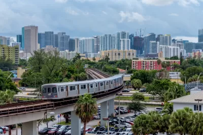
Rene Rodriguez and Sarah Moreno share news of a new mapping tool by researchers at the University of Miami that locates vacant and underutilized land in Mimi-Dade County.
Rodriguez and Moreno share the data illustrated by the mapping tool as counter evidence to claims by local developers about land scarcity in the county. According to the new Land Access for Neighborhood Development tool (LAND), "there are actually 500 million square feet of vacant or underutilized land scattered across Miami-Dade County. The land is either publicly or institutionally owned."
The LAND tool is the work of the Miami Housing Solutions Lab at the University of Miami's Office of Civic and Community Engagement (CCE).
"The program, which is free to use and available to the public, collects and visualizes data from the Miami-Dade County Property Appraiser," according to Ridriguez and Moreno. "It allows users to apply various filters to searches, so they can distinguish vacant, available city lots from county-owned land previously used but no longer needed by government agencies. (They’re called surplus lots.)"
FULL STORY: Developers say there’s no vacant land in Miami. This tool shows half a billion square feet.

District By District, Maps Trace Neighborhood Opportunity Across the U.S.
Down to the level of individual census tracts, a team of researchers has developed national maps showing where upward mobility is probable, and where it isn't.
Miami Loses Population for the First Time Since 1970
Already one of the nation’s hottest real estate markets before the Covid-19 pandemic, the region became unaffordable for many middle-income households in the last few years.

How the National Park Service Uses GIS
A new book demonstrates how the National Park Service uses GIS technology to meet its mission and showcases a selection of maps used for effectively managing national parks.

Alabama: Trump Terminates Settlements for Black Communities Harmed By Raw Sewage
Trump deemed the landmark civil rights agreement “illegal DEI and environmental justice policy.”

Planetizen Federal Action Tracker
A weekly monitor of how Trump’s orders and actions are impacting planners and planning in America.

Why Should We Subsidize Public Transportation?
Many public transit agencies face financial stress due to rising costs, declining fare revenue, and declining subsidies. Transit advocates must provide a strong business case for increasing public transit funding.

Understanding Road Diets
An explainer from Momentum highlights the advantages of reducing vehicle lanes in favor of more bike, transit, and pedestrian infrastructure.

New California Law Regulates Warehouse Pollution
A new law tightens building and emissions regulations for large distribution warehouses to mitigate air pollution and traffic in surrounding communities.

Phoenix Announces Opening Date for Light Rail Extension
The South Central extension will connect South Phoenix to downtown and other major hubs starting on June 7.
Urban Design for Planners 1: Software Tools
This six-course series explores essential urban design concepts using open source software and equips planners with the tools they need to participate fully in the urban design process.
Planning for Universal Design
Learn the tools for implementing Universal Design in planning regulations.
Caltrans
Smith Gee Studio
Institute for Housing and Urban Development Studies (IHS)
City of Grandview
Harvard GSD Executive Education
Toledo-Lucas County Plan Commissions
Salt Lake City
NYU Wagner Graduate School of Public Service