


A Reddit user created a transit map of the San Francisco Bay Area that connects Taco Bell locations, which, unlike rail public transit, have reached every corner of the region.
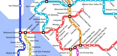
Reddit user u/Epicapabilities, actually 16-year-old Jeff McGough, a high school student from Minnesota, created a Taco Bell-connected fantasy map of rail transit in the San Francisco Bay Area and environs that won attention recently. The map spreads from Dixon to Rio Vista to Cloverdale to Manteca to Monterey, with all the Tracys, Gilroys, Redwood Citys, Santa Rosas, and Cordelias between included.
I grew up near the Clayton Rd station imagined on the map and frequented the Taco Bell in question before I knew any better, but I don't see an advertisement for bad fast food in this map. I see the fantasy transit map of the region I grew up in if cars had somehow skipped the 20th century. Sure, there are too many transfers on this map. I'm sure people in Vallejo and Benicia would love a one-seat ride into The City.
Still. Imagine such a world. Then again, it's hard to imagine Taco Bell being so ubiquitous in a world without cars. Is that a win-win?
McGough also created a similar map for Whataburger locations in Austin, Target in the Twin Cities, and Taco Bells in cities all over the country. Taco Bell picked up McGough's work for its blog.
FULL STORY: If Taco Bell connected their locations with a rail system


Friday Eye Candy: Mapping the Nation's Internet Trolls
Finally, we know where Internet trolls come from—no, not the basements of parents' houses.
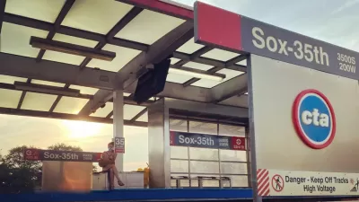
$2 Billion Federal Grant for Red Line Extension Project to Chicago’s South Side
A plan to extend the Chicago Transit Authority (CTA) Red Line 5.6 miles to the south won a $2 billion grant from the federal government.
Virginia Passenger Rail Sets Ridership Records, Seeks More Wins
Virginia’s commitment to intercity rail is paying off in record ridership numbers, but more work will be necessary to achieve the state’s ambitions for passenger rail.

Alabama: Trump Terminates Settlements for Black Communities Harmed By Raw Sewage
Trump deemed the landmark civil rights agreement “illegal DEI and environmental justice policy.”

Planetizen Federal Action Tracker
A weekly monitor of how Trump’s orders and actions are impacting planners and planning in America.

Why Should We Subsidize Public Transportation?
Many public transit agencies face financial stress due to rising costs, declining fare revenue, and declining subsidies. Transit advocates must provide a strong business case for increasing public transit funding.

Understanding Road Diets
An explainer from Momentum highlights the advantages of reducing vehicle lanes in favor of more bike, transit, and pedestrian infrastructure.

New California Law Regulates Warehouse Pollution
A new law tightens building and emissions regulations for large distribution warehouses to mitigate air pollution and traffic in surrounding communities.

Phoenix Announces Opening Date for Light Rail Extension
The South Central extension will connect South Phoenix to downtown and other major hubs starting on June 7.
Urban Design for Planners 1: Software Tools
This six-course series explores essential urban design concepts using open source software and equips planners with the tools they need to participate fully in the urban design process.
Planning for Universal Design
Learn the tools for implementing Universal Design in planning regulations.
Caltrans
Smith Gee Studio
Institute for Housing and Urban Development Studies (IHS)
City of Grandview
Harvard GSD Executive Education
Toledo-Lucas County Plan Commissions
Salt Lake City
NYU Wagner Graduate School of Public Service