


With the news of the UN Intergovernmental Panel on Climate Change's report predicting dire consequences of climate change and seal level rise still fresh, the city of Boston has released a plan for how it will shore up its coastline.

"The city of Boston has unveiled a new vision for protecting the city’s 47 miles of shoreline and has used New York’s SCAPE Landscape Architecture to master plan it," reports Jonathan Hilburg.
"The plan, 'Resilient Boston Harbor,' was presented yesterday by Mayor Martin J. Walsh before the Greater Boston Chamber of Commerce. It builds off of the Climate Ready Boston 2070 flood maps, coastal resilience neighborhood studies, and the work done under the Imagine Boston 2030 initiative," adds Hilburg.
Hilburg shares renderings from the plan and details about the plan's approach to resilience.
FULL STORY: Boston taps SCAPE for a resilient harbor master plan


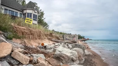
Preparing Boston for Future Floods
Boston Mayor, Martin Walsh's, climate change plan is one of the most thorough in the country. The question remains: Will any of the plan be put into action?
Boston Hopes to Make it Easier for Developers to Prepare for Rising Seas
Several agencies with the city of Boston will begin studying how to retrofit the city's building codes to prepare for the impacts of climate change.
How US Cities Can Prepare for Climate Disasters
Resilience, encompassing infrastructure, governance, economic strength, and social cohesion, is critical for cities to mitigate rising climate risks like flooding, wildfires, and heat, ensuring long-term recovery and adaptability.

Alabama: Trump Terminates Settlements for Black Communities Harmed By Raw Sewage
Trump deemed the landmark civil rights agreement “illegal DEI and environmental justice policy.”

Planetizen Federal Action Tracker
A weekly monitor of how Trump’s orders and actions are impacting planners and planning in America.

The 120 Year Old Tiny Home Villages That Sheltered San Francisco’s Earthquake Refugees
More than a century ago, San Francisco mobilized to house thousands of residents displaced by the 1906 earthquake. Could their strategy offer a model for the present?

Ken Jennings Launches Transit Web Series
The Jeopardy champ wants you to ride public transit.

BLM To Rescind Public Lands Rule
The change will downgrade conservation, once again putting federal land at risk for mining and other extractive uses.

Indy Neighborhood Group Builds Temporary Multi-Use Path
Community members, aided in part by funding from the city, repurposed a vehicle lane to create a protected bike and pedestrian path for the summer season.
Urban Design for Planners 1: Software Tools
This six-course series explores essential urban design concepts using open source software and equips planners with the tools they need to participate fully in the urban design process.
Planning for Universal Design
Learn the tools for implementing Universal Design in planning regulations.
Clanton & Associates, Inc.
Jessamine County Fiscal Court
Institute for Housing and Urban Development Studies (IHS)
City of Grandview
Harvard GSD Executive Education
Toledo-Lucas County Plan Commissions
Salt Lake City
NYU Wagner Graduate School of Public Service