


The National Geodetic Survey maintains and updates critical spatial reference systems used extensively in both the public and private sectors.
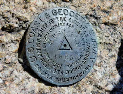
Federal funding and staffing cuts are threatening to have devastating effects on the work of the National Geodetic Survey (NGS), the nation’s oldest scientific agency and one responsible for accurately mapping and measuring the world.
Although little known, the agency’s work is crucial “As the world turns more and more toward operations that need precise coordinate systems like the ones NGS provides,” explains Molly Taft in Wired.
Founded in 1807 by Thomas Jefferson, NGS has expanded its original mapping mission to include “calculating the shape of the Earth, its orientation in space, and its gravitational field.” It is responsible for maintaining the National Spatial Reference System, which informs calculations for crucial infrastructure but has become outdated since its creation in the 1980s. “Ensuring hyper-accurate location is also becoming increasingly important as more and more industries are building up around automation that relies on precise spatial measurements.” The agency was planning to roll out an update of the system to ensure better accuracy.
Now, the agency has lost over a quarter of its staff. “A NOAA budget proposal from the White House Office of Management and Budget sent to the agency in April cuts the budget for the National Ocean Service, which houses NGS, by more than half.”
FULL STORY: Trump Cuts Are Killing a Tiny Office That Keeps Measurements of the World Accurate


New Book Shows How Geographic Technology Tackles Global Challenges
In his new book, Jack Dangermond explores the transformative impact of GIS technology in solving global challenges through spatial data, highlighting its widespread application across sectors and its potential to design sustainable futures.

Building Healthier Communities: The Role of GIS in Park Planning
Integrating Geographic Information Systems (GIS) into park planning enhances community health by promoting physical activity, supporting mental well-being, fostering social connectedness, and addressing public health crises and climate change.
New Book Highlights How GIS Improves Outcomes
Esri Press recently published a digital book called Mapping the Nation which demonstrates how a geographic approach guides important decisions and addresses challenges around the globe.

Rethinking Redlining
For decades we have blamed 100-year-old maps for the patterns of spatial racial inequity that persist in American cities today. An esteemed researcher says: we’ve got it all wrong.

Planetizen Federal Action Tracker
A weekly monitor of how Trump’s orders and actions are impacting planners and planning in America.

Montreal Mall to Become 6,000 Housing Units
Place Versailles will be transformed into a mixed-use complex over the next 25 years.

Santa Clara County Dedicates Over $28M to Affordable Housing
The county is funding over 600 new affordable housing units via revenue from a 2016 bond measure.

Why a Failed ‘Smart City’ Is Still Relevant
A Google-backed proposal to turn an underused section of Toronto waterfront into a tech hub holds relevant lessons about privacy and data.

When Sears Pioneered Modular Housing
Kit homes sold in catalogs like Sears and Montgomery Ward made homeownership affordable for midcentury Americans.
Urban Design for Planners 1: Software Tools
This six-course series explores essential urban design concepts using open source software and equips planners with the tools they need to participate fully in the urban design process.
Planning for Universal Design
Learn the tools for implementing Universal Design in planning regulations.
City of Camden Redevelopment Agency
City of Astoria
Transportation Research & Education Center (TREC) at Portland State University
Regional Transportation Commission of Southern Nevada
Toledo-Lucas County Plan Commissions