


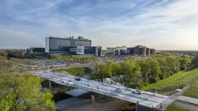
Indianapolis is developing a new Greenways Strategic Implementation Plan to expand, connect, and modernize its trail system, aiming for over 250 miles of greenways that support sustainability, mobility, and community well-being.

Indianapolis is advancing a major update to its greenway system through the Greenways Strategic Implementation Plan, led by the Department of Public Works (Indy DPW). Building on the 2014 Full Circle Master Plan, the new initiative aims to improve trail connectivity, enhance sustainability, and support economic development. As reported by Hanna Rauworth, the vision includes expanding the city’s greenway network to over 250 miles, creating a more integrated and resilient urban environment for all residents.
Key components of the plan include updating zoning codes to support trail-oriented development, identifying funding strategies, standardizing maintenance protocols, and modernizing design standards. The initiative will also address trail gaps, expand infrastructure, and develop a long-term governance structure for planning and operations. By emphasizing equitable access and environmental integration, the plan seeks to promote public health and neighborhood vitality.
The Greenways Strategic Implementation Plan began in July 2024 and is scheduled for completion by the end of 2025. By 2028, Marion County is expected to offer over 120 miles of greenways, enhancing connections between trails, neighborhoods, and transportation systems. This effort ensures that Indianapolis continues to grow a robust, inclusive, and future-ready trail network for generations to come.
FULL STORY: Indy Greenways: New plan aims to expand and connect trail system


Knoxville Dedicates $1M to New Greenway
The proposed greenway would run along North Broadway and connect to 125 miles of existing trails.
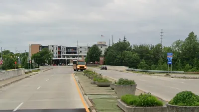
New Indianapolis Bridge Prioritizes Walking, Biking
Over half the surface of the Fall Creek Bridge is devoted to walking and biking paths.
Indy Neighborhood Group Builds Temporary Multi-Use Path
Community members, aided in part by funding from the city, repurposed a vehicle lane to create a protected bike and pedestrian path for the summer season.

Rethinking Redlining
For decades we have blamed 100-year-old maps for the patterns of spatial racial inequity that persist in American cities today. An esteemed researcher says: we’ve got it all wrong.

Planetizen Federal Action Tracker
A weekly monitor of how Trump’s orders and actions are impacting planners and planning in America.

Montreal Mall to Become 6,000 Housing Units
Place Versailles will be transformed into a mixed-use complex over the next 25 years.

Santa Clara County Dedicates Over $28M to Affordable Housing
The county is funding over 600 new affordable housing units via revenue from a 2016 bond measure.

Why a Failed ‘Smart City’ Is Still Relevant
A Google-backed proposal to turn an underused section of Toronto waterfront into a tech hub holds relevant lessons about privacy and data.

When Sears Pioneered Modular Housing
Kit homes sold in catalogs like Sears and Montgomery Ward made homeownership affordable for midcentury Americans.
Urban Design for Planners 1: Software Tools
This six-course series explores essential urban design concepts using open source software and equips planners with the tools they need to participate fully in the urban design process.
Planning for Universal Design
Learn the tools for implementing Universal Design in planning regulations.
City of Camden Redevelopment Agency
City of Astoria
Transportation Research & Education Center (TREC) at Portland State University
Regional Transportation Commission of Southern Nevada
Toledo-Lucas County Plan Commissions