


The region is becoming more vulnerable to flooding and storm damage due in part to climate change and warmer seas.

.jpg)
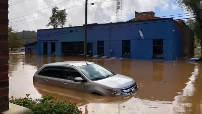
The damage caused by last week’s powerful Hurricane Helene in Florida’s ‘Big Bend’ region highlights a growing threat for the area, reports Julia Jacobo for ABC 7.
“The underwater geology of the Gulf of Mexico leaves much of the low-lying coast unguarded against a massive influx of seawater. The continental shelf of the Florida Gulf Coast extends quite far offshore - up to 150 miles in some spots, according to the National Oceanographic and Atmospheric Administration (NOAA) - leaving the shallow waters nowhere to go.” The storm surge from Hurricane Helene is projected to be as high as 20 feet in some parts of the region.
The Big Bend is in increasing danger due to currents from the Gulf of Mexico, a loss of seagrass, and rising sea levels. The U.S. coastline could experience an average rise in sea level of about 11 inches between 2020 and 2025, according to a federal report. “While many factors contribute to the magnitude and impacts of storm surge and coastal flooding, average sea levels for many Gulf Coast communities are more than six inches higher today than they were just a few decades ago, data shows.”
Meanwhile, warmer ocean surface temperatures are fueling stronger hurricanes. “Warmer than normal oceans hold a lot of extra energy that these storms can feed on, and about 80% of major hurricanes, between Categories 3 and 5, undergo rapid intensification, defined as an increase in the maximum sustained winds of a tropical cyclone of about 35 mph or more in a 24-hour period.”
FULL STORY: Hurricane Helene: Climate change is making Florida's Big Bend more vulnerable to tropical threats

Love Letter to Asheville
A River Arts District resident and urbanist reflects on her experience in the former “climate haven” in the aftermath of Hurricane Helene.
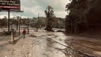
‘Climate Havens’ Not Safe From Hurricane Helene’s Destruction
Parts of North Carolina previously considered immune to the impact of hurricanes experienced historic flooding in the aftermath of the storm.
Will Hurricanes Drive Away Florida’s Retirees?
Some children of Florida retirees are urging their parents to leave hurricane-prone areas for safer regions.

Trump Administration Could Effectively End Housing Voucher Program
Federal officials are eyeing major cuts to the Section 8 program that helps millions of low-income households pay rent.

Planetizen Federal Action Tracker
A weekly monitor of how Trump’s orders and actions are impacting planners and planning in America.

Ken Jennings Launches Transit Web Series
The Jeopardy champ wants you to ride public transit.

Sacramento Plans ‘Quick-Build’ Road Safety Projects
The city wants to accelerate small-scale safety improvements that use low-cost equipment to make an impact at dangerous intersections.

How Project Connect Would Change ‘The Drag’
A popular — and sometimes deadly — Austin road will exchange car lanes for light rail.

Milwaukee Road to Get Complete Streets Upgrades
The city will reduce vehicle lanes and build a protected multi-use trail including bioswales and other water retention features on its ‘secret highway.’
Urban Design for Planners 1: Software Tools
This six-course series explores essential urban design concepts using open source software and equips planners with the tools they need to participate fully in the urban design process.
Planning for Universal Design
Learn the tools for implementing Universal Design in planning regulations.
Ada County Highway District
Clanton & Associates, Inc.
Jessamine County Fiscal Court
Institute for Housing and Urban Development Studies (IHS)
City of Grandview
Harvard GSD Executive Education
Toledo-Lucas County Plan Commissions
Salt Lake City
NYU Wagner Graduate School of Public Service