


A nationwide ‘digital zoning atlas’ shows how different zoning districts overlap with and affect transportation, infrastructure, and housing affordability.
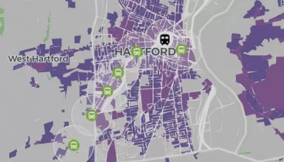
Inspired by a Connecticut project led by Cornell professor Sara Bronin, a group of academics, advocates, and policymakers are creating a nationwide ‘zoning atlas’ that will visualize local zoning codes and highlight how zoning rules impact the housing market. As Carl Smith reports in Governing, “Connecticut has the only statewide atlas that has been completed to date, but projects are already underway in California, Hawaii, Massachusetts, Montana, New Hampshire, New York and Ohio.”
The Connecticut project led to concrete policy changes, according to DesegregateCT director Peter Harrison. “You click and change from single-family housing allowed as-of-right to multifamily as-of-right, and the map goes blank — the story we’re trying to tell becomes real at a scale and speed that we could not do without it.”
The national effort is bringing together researchers from other states to map similar data. “This will help researchers who want to understand zoning’s impact on housing, education, environmental quality, climate change, transportation patterns, the economy and even government finances.”
Bronin and her collaborators hope that the atlas will provide a data-driven tool to help policymakers make informed decisions. “Our hope is that we’re laying the groundwork for many different people to use this information to guide decisions and also to engage people in the process of planning.”
FULL STORY: Digital Atlas Reveals Zoning’s Impact on Affordable Housing


DC Residents Want Affordability Over ‘Character’
A poll finds that most residents want to see changes in zoning and land use laws that unlock more housing construction in the District and improve affordability.

NYC’s Proposed Zoning Reforms Lag Behind Other Cities
Cities like Austin and Minneapolis are making major changes to their zoning codes to encourage housing construction, but New York’s proposed reforms are far less ambitious.

Analysis: Localized Upzoning Less Effective
Changing zoning rules for a small number of parcels can increase land values and housing costs without boosting the housing supply.

Study: Maui’s Plan to Convert Vacation Rentals to Long-Term Housing Could Cause Nearly $1 Billion Economic Loss
The plan would reduce visitor accommodation by 25,% resulting in 1,900 jobs lost.

North Texas Transit Leaders Tout Benefits of TOD for Growing Region
At a summit focused on transit-oriented development, policymakers discussed how North Texas’ expanded light rail system can serve as a tool for economic growth.

Why Should We Subsidize Public Transportation?
Many public transit agencies face financial stress due to rising costs, declining fare revenue, and declining subsidies. Transit advocates must provide a strong business case for increasing public transit funding.

How to Make US Trains Faster
Changes to boarding platforms and a switch to electric trains could improve U.S. passenger rail service without the added cost of high-speed rail.

Columbia’s Revitalized ‘Loop’ Is a Hub for Local Entrepreneurs
A focus on small businesses is helping a commercial corridor in Columbia, Missouri thrive.

Invasive Insect Threatens Minnesota’s Ash Forests
The Emerald Ash Borer is a rapidly spreading invasive pest threatening Minnesota’s ash trees, and homeowners are encouraged to plant diverse replacement species, avoid moving ash firewood, and monitor for signs of infestation.
Urban Design for Planners 1: Software Tools
This six-course series explores essential urban design concepts using open source software and equips planners with the tools they need to participate fully in the urban design process.
Planning for Universal Design
Learn the tools for implementing Universal Design in planning regulations.
City of Santa Clarita
Ascent Environmental
Institute for Housing and Urban Development Studies (IHS)
City of Grandview
Harvard GSD Executive Education
Toledo-Lucas County Plan Commissions
Salt Lake City
NYU Wagner Graduate School of Public Service