


Digital mapping tools like Google Street View often obscure the realities of cities and concentrate their resources in the wealthiest countries, effectively ‘erasing’ some places from the global map.
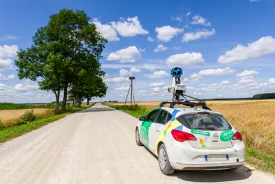
Writing in ArchDaily, Matthew Maganga highlights the failures of modern mapping tools such as Google Street View, which can literally leave some places off the map and perpetuate unequal systems of power. “Historically, far before the realm of today’s digital technologies, mapping has functioned as a method of control. This control seeped out into how unmapped spaces were viewed, as European colonial powers termed unmapped land as terra nullius and sought to, through mapping, further their imperial commercial interests.”
Today, “In a ‘post-colonial’ twenty-first-century, neo-colonialism means that some of these unmapped cities are greatly reliant on a tourism industry that seeks to attract travelers mainly from the countries of the Global North.” According to Maganga, “In Africa, only 13 countries have been mapped by Google Street View. Almost all of Central America has yet to be mapped. Much of Asia and the Middle East is similarly unavailable on Google Street View.”
In other situations, Google Street View only shows the “sanitized” parts of a city, writes Maganga. In some places, Google Street View omits informal settlements. “This form of urban cartography essentially ignores those who live in examples of less ‘formal’ architecture, exacerbating what can only be termed as an urban digital divide where places not visible on platforms such as Google Street View are in turn then forgotten by governments and political powers.”
Maganga cautions that it’s crucial to remember that “Mapping has always been biased – it’s far from a neutral endeavor.” Planners and cartographers must remember that their tools, if not deployed with care, can reinforce systems of injustice.
FULL STORY: Invisible Landscapes: When Digital Tools Fail to Document

Top Websites for Urban Planning - 2022
Every year, Planetizen collects the websites breaking new digital ground in the world of planning and related fields.

Analyzing Lynch's City Imageability in the Digital Age
Mahbubur Meenar of Rowan University writes about a recent article he co-authored in the Journal of Planning Education and Research

Placekeeping: Setting a New Precedent for City Planners
How a preservation-based approach to redevelopment and urban design can prevent displacement and honor legacy communities.

Trump Administration Could Effectively End Housing Voucher Program
Federal officials are eyeing major cuts to the Section 8 program that helps millions of low-income households pay rent.

Planetizen Federal Action Tracker
A weekly monitor of how Trump’s orders and actions are impacting planners and planning in America.

Ken Jennings Launches Transit Web Series
The Jeopardy champ wants you to ride public transit.

Crime Continues to Drop on Philly, San Francisco Transit Systems
SEPTA and BART both saw significant declines in violent crime in the first quarter of 2025.

How South LA Green Spaces Power Community Health and Hope
Green spaces like South L.A. Wetlands Park are helping South Los Angeles residents promote healthy lifestyles, build community, and advocate for improvements that reflect local needs in historically underserved neighborhoods.

Sacramento Plans ‘Quick-Build’ Road Safety Projects
The city wants to accelerate small-scale safety improvements that use low-cost equipment to make an impact at dangerous intersections.
Urban Design for Planners 1: Software Tools
This six-course series explores essential urban design concepts using open source software and equips planners with the tools they need to participate fully in the urban design process.
Planning for Universal Design
Learn the tools for implementing Universal Design in planning regulations.
Heyer Gruel & Associates PA
Ada County Highway District
Institute for Housing and Urban Development Studies (IHS)
City of Grandview
Harvard GSD Executive Education
Toledo-Lucas County Plan Commissions
Salt Lake City
NYU Wagner Graduate School of Public Service