


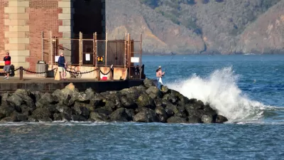
A controversial proposed housing development in Newark exemplifies the struggle between increasing housing supply and protecting vulnerable shoreline communities from flooding.

(NRCS_Photo_Gallery).jpg)
Although sea levels could rise by at least a foot in the next decade, reports Ezra David Romero, a developer is planning to go ahead with a controversial housing development on the shores of San Francisco Bay.
The project, which would build 469 badly needed housing units in Newark, would be located in a federal flood zone just outside the jurisdiction of the Bay Conservation and Development Commission. Despite the developer's plan to "drive in around 100,000 truckloads of dirt to raise the homes above potential stormwaters" and "line the banks with rocks to protect houses from waves," environmental groups say the measures aren't enough to mitigate anticipated damage.
In addition to the threat posed to the homes themselves, environmentalists argue that building the project would destroy local wetlands that serve as crucial natural flood protection. Thanks to urban development, only 10 percent of marshland in San Francisco Bay remains today. While the city has acknowledged the risk, it is also looking to the county and regional authorities to implement 'area-wide' mitigation projects.
Experts recommend clearer state and regional guidelines for approaching developments in coastal areas. "BCDC’s new regional sea level rise adaptation plan, Bay Adapt, includes a potential fix and is a road map for agencies and cities to create new policies to interpret the effects of climate change better."
FULL STORY: The Bay Is Rising. Newark Residents Wonder Why The City Plans to Develop Its Shoreline

Bay Area's First Climate Adaptation Project Could Be a North Bay Highway
State Route 37 is a vital highway connecting four North Bay counties plagued by two unrelated problems: chronic flooding during high tides and traffic congestion. Fixing the problem will set a precedent for Bay Area climate adaptation.
An In-Depth Look at Sea Level Rise in the San Francisco Bay Area
The San Francisco Chronicle gives feature-length, in-depth treatment to the looming dangers of sea level rise, which are more likely to encroach on the built and natural environments of the Bay Area with every passing year.

How Cities Can Curb Climate Change and Protect Vulnerable Residents
A new U.N. report urges cities to upgrade their infrastructure to bolster climate resilience and build more sustainable, climate-friendly places.

Trump Administration Could Effectively End Housing Voucher Program
Federal officials are eyeing major cuts to the Section 8 program that helps millions of low-income households pay rent.

Planetizen Federal Action Tracker
A weekly monitor of how Trump’s orders and actions are impacting planners and planning in America.

Ken Jennings Launches Transit Web Series
The Jeopardy champ wants you to ride public transit.

Opinion: Transit Agencies Must View Service Cuts as Last Resort
Reducing service could cripple transit systems by pushing more riders to consider car ownership, making future recovery even less certain.

‘Smart Surfaces’ Policy Guide Offers Advice for Building and Maintaining Urban Tree Canopies
Healthy, robust tree canopies can reduce the impacts of extreme heat and improve air quality.

New Jersey Lawsuit Targets Rent-Setting Algorithms
The state of New Jersey is taking legal action against landlords and companies that engage in what the state’s Attorney General alleges is illegal rent fixing.
Urban Design for Planners 1: Software Tools
This six-course series explores essential urban design concepts using open source software and equips planners with the tools they need to participate fully in the urban design process.
Planning for Universal Design
Learn the tools for implementing Universal Design in planning regulations.
Heyer Gruel & Associates PA
Ada County Highway District
Institute for Housing and Urban Development Studies (IHS)
City of Grandview
Harvard GSD Executive Education
Toledo-Lucas County Plan Commissions
Salt Lake City
NYU Wagner Graduate School of Public Service