


State Route 37 is a vital highway connecting four North Bay counties plagued by two unrelated problems: chronic flooding during high tides and traffic congestion. Fixing the problem will set a precedent for Bay Area climate adaptation.
The 21-mile highway, known as SR 37, connects the counties of Marin, Sonoma, Solano, and Napa while skirting the San Pablo Bay. It suffers two unrelated problems: flooding caused by high tides and traffic congestion.
Fixing the highway's problems "to avoid its potential loss in the next 20 years because of flooding will be our first regional foray into adapting to sea level rise — an issue that will threaten most of our shoreline infrastructure, coastal ecosystems and population centers," write University of California at Davis ecologist, Fraser Shilling, co-director of the Road Ecology Center, and Steven Moore, a civil engineer and vice chair of the State Water Resources Control Board, in this cover story for the Insight section of Sunday's San Francisco Chronicle.
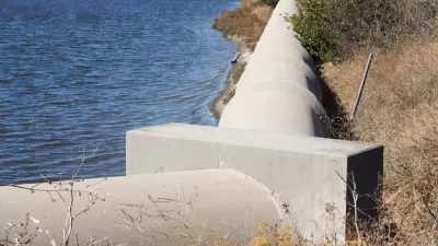
Today the highway is built atop a berm, an outdated method of building roads across marshes and waterways that constricts the ability of the bay to improve water quality by filtering out pollutants, produce more fish and wildlife, and absorb floods.
Currently, some are advocating for raising the highway [$1.3 billion] in its current location, with the primary goal of increasing traffic flows, at least in the short term. Although cheaper than the bridge-causeway alternative [$4 billion], the berm approach misses the more holistic opportunities of reconnecting marshlands to the bay and taking advantage of the flood-absorbing capacity of thousands of acres of these publicly owned wetlands.
One is reminded of the catastrophic damage done by Hurricane Harvey to Houston last month, caused in part by development choices made by the city and region. Mitigating flooding by connecting the marshes to the bay by either the causeway, which would still impact marshes, or what Shilling and Moore call the North Bay Bridge, may enable the project to tap the 2016 regional Measure AA funds for wetland restoration and adaptation to sea level rise.
Tolling an option
In 2015, the congestion management agencies of the four affected counties "agreed to form a partnership ... to develop an expedited funding, financing and project implementation strategy for the reconstruction of SR 37 to withstand rising seas and storm surges while improving mobility and safety along the route," according to the Sonoma County Transportation Authority.
A post last May indicated they are explore financing options which reportedly include the use of tolling and public-private partnerships.
FULL STORY: Rebuild State Route 37 to address sea level rise and traffic


Bay Area Developments at Risk From Sea Level Rise
A controversial proposed housing development in Newark exemplifies the struggle between increasing housing supply and protecting vulnerable shoreline communities from flooding.
Bay Area to Create Regional Plan for Sea-Level Rise
California wants the region to work together to deal with the impacts of climate change.
An In-Depth Look at Sea Level Rise in the San Francisco Bay Area
The San Francisco Chronicle gives feature-length, in-depth treatment to the looming dangers of sea level rise, which are more likely to encroach on the built and natural environments of the Bay Area with every passing year.

Study: Maui’s Plan to Convert Vacation Rentals to Long-Term Housing Could Cause Nearly $1 Billion Economic Loss
The plan would reduce visitor accommodation by 25,% resulting in 1,900 jobs lost.

North Texas Transit Leaders Tout Benefits of TOD for Growing Region
At a summit focused on transit-oriented development, policymakers discussed how North Texas’ expanded light rail system can serve as a tool for economic growth.

Using Old Oil and Gas Wells for Green Energy Storage
Penn State researchers have found that repurposing abandoned oil and gas wells for geothermal-assisted compressed-air energy storage can boost efficiency, reduce environmental risks, and support clean energy and job transitions.

Santa Barbara Could Build Housing on County Land
County supervisors moved forward a proposal to build workforce housing on two county-owned parcels.

San Mateo Formally Opposes Freeway Project
The city council will send a letter to Caltrans urging the agency to reconsider a plan to expand the 101 through the city of San Mateo.

A Bronx Community Fights to Have its Voice Heard
After organizing and giving input for decades, the community around the Kingsbridge Armory might actually see it redeveloped — and they want to continue to have a say in how it goes.
Urban Design for Planners 1: Software Tools
This six-course series explores essential urban design concepts using open source software and equips planners with the tools they need to participate fully in the urban design process.
Planning for Universal Design
Learn the tools for implementing Universal Design in planning regulations.
Ascent Environmental
Borough of Carlisle
Institute for Housing and Urban Development Studies (IHS)
City of Grandview
Harvard GSD Executive Education
Toledo-Lucas County Plan Commissions
Salt Lake City
NYU Wagner Graduate School of Public Service