


The massive Port Lands infrastructure project will transform an industrial area by carving out a new island.
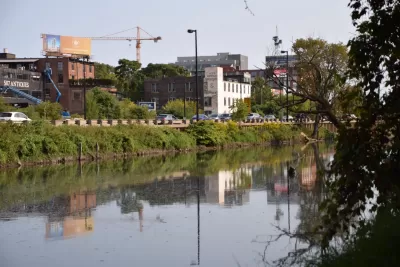
Kenyon Wallace takes a closer look at the Port Lands Flood Protection Project, a $1.25 billion project to naturalize the Don River pathway and help with flood control through construction of a river valley that will result in an island at the river’s mouth.
"The Port Lands, located south of Lake Shore Boulevard between Leslie Street in the east and Cherry Street in the west, are a primarily industrial and commercial neighbourhood built on landfill that was once home to oil tank farms, factories and a city incinerator," writes Wallace.
He describes the different phases of the project in more detail, including the excavation of the river valley, treatment of groundwater, and landscaping along the edge of the river. The entire area will also be raised and will undergo soil stabilization.
"The new island, named Villiers Island, will feature parklands, walking and biking trails, and residential and commercial real estate (not to mention great views of the city skyline). It will also feature the only natural shoreline within the inner harbour, allowing for easy entry into Lake Ontario with canoes and kayaks," says Wallace.
FULL STORY: How do you build an island in Toronto?

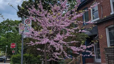
The Most Popular Tree on Google?
Meet Rodney: the Toronto tree getting rave reviews.

Expanding the Concept of Transit-Oriented Development: Lessons from Abroad
Keeping transit planning and development siloed can limit opportunities to build affordable housing and vibrant neighborhoods.

3D Modeling Aids in Predicting Hurricane Damage
Texas researchers are testing the tool in Galveston, where Hurricane Ike caused billions in damage in 2008.

Trump Administration Could Effectively End Housing Voucher Program
Federal officials are eyeing major cuts to the Section 8 program that helps millions of low-income households pay rent.

Planetizen Federal Action Tracker
A weekly monitor of how Trump’s orders and actions are impacting planners and planning in America.

Ken Jennings Launches Transit Web Series
The Jeopardy champ wants you to ride public transit.

Washington Legislature Passes Rent Increase Cap
A bill that caps rent increases at 7 percent plus inflation is headed to the governor’s desk.

From Planning to Action: How LA County Is Rethinking Climate Resilience
Chief Sustainability Officer Rita Kampalath outlines the County’s shift from planning to implementation in its climate resilience efforts, emphasizing cross-departmental coordination, updated recovery strategies, and the need for flexible funding.

New Mexico Aging Department Commits to Helping Seniors Age ‘In Place’ and ‘Autonomously’ in New Draft Plan
As New Mexico’s population of seniors continues to grow, the state’s aging department is proposing expanded initiatives to help seniors maintain their autonomy while also supporting family caregivers.
Urban Design for Planners 1: Software Tools
This six-course series explores essential urban design concepts using open source software and equips planners with the tools they need to participate fully in the urban design process.
Planning for Universal Design
Learn the tools for implementing Universal Design in planning regulations.
Heyer Gruel & Associates PA
Ada County Highway District
Institute for Housing and Urban Development Studies (IHS)
City of Grandview
Harvard GSD Executive Education
Toledo-Lucas County Plan Commissions
Salt Lake City
NYU Wagner Graduate School of Public Service