


A new analysis of inequality looks at where people go and how they spend their time.

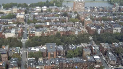
Researchers from the MIT Media Lab have developed a map that measures segregation by considering the places frequented by people in different income groups in Boston, reports Tanvi Misra:
The resulting “Atlas of Inequality” reveals a taxonomy of places in the city that tend to be more diverse and those that tend to be more economically homogenous. Among the most equal places, [Esteban] Moro and his colleagues found, are museums and airports. Schools, on the other hand, are among the least.
The map shows that establishments can be located very close to one another — two coffeeshops on either side of the street, for example — but the economic backgrounds of the people using those spaces can differ considerably. The researchers say the findings suggest that segregation should not just be measured at the broader census-tract level since micro-level interactions are important as well.
"Where we get coffee, where we buy groceries, and where we grab take-out often reflect our choices, which determine the kinds of people we interact with every day. Or, these habits reflect our constraints—and show what places are accessible and welcoming to certain groups of people," notes Misra.
FULL STORY: The 'Atlas of Inequality’ Maps Micro-Level Segregation


The Basement Apartments of Seoul’s Urban Poor
The lives of Seoul's poorest residents in squalid below-ground housing are brought out of the shadows in the film "Parasite."

Boston's Seaport District Still Lacking Diversity
The glitzy new neighborhood doesn’t cater to all Boston residents, according to a new survey.
Study Shows Segregation Linked to Housing Shortage in Massachusetts
A study from the Boston Foundation shows that besides homelessness and housing costs, Massachusetts housing debt also fuels the racial wealth gap and segregation.

Trump Administration Could Effectively End Housing Voucher Program
Federal officials are eyeing major cuts to the Section 8 program that helps millions of low-income households pay rent.

Planetizen Federal Action Tracker
A weekly monitor of how Trump’s orders and actions are impacting planners and planning in America.

Ken Jennings Launches Transit Web Series
The Jeopardy champ wants you to ride public transit.

California Invests Additional $5M in Electric School Buses
The state wants to electrify all of its school bus fleets by 2035.

Austin Launches $2M Homelessness Prevention Fund
A new grant program from the city’s Homeless Strategy Office will fund rental assistance and supportive services.

Alabama School Forestry Initiative Brings Trees to Schoolyards
Trees can improve physical and mental health for students and commnity members.
Urban Design for Planners 1: Software Tools
This six-course series explores essential urban design concepts using open source software and equips planners with the tools they need to participate fully in the urban design process.
Planning for Universal Design
Learn the tools for implementing Universal Design in planning regulations.
Ada County Highway District
Clanton & Associates, Inc.
Jessamine County Fiscal Court
Institute for Housing and Urban Development Studies (IHS)
City of Grandview
Harvard GSD Executive Education
Toledo-Lucas County Plan Commissions
Salt Lake City
NYU Wagner Graduate School of Public Service