


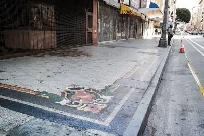
An app called Surveyor is making it easier to collect better data on curbs.
Kyle Wiggers reports on the startup Coord, which developed an app called Surveyor to locate curbs and catalog information about them. Existing data leaves a lot to be desired, says Wiggers:
The trouble is, the data’s often incomplete, and in some cases erroneous. Trees and other obstructions obscure street signs. Miscalibrated vehicle headings make it tough (and sometimes impossible) to suss out locations. And curb cuts, loading zones, meter prices, and curb paint aren’t consistently visible from street level.
The app allows users to mark the start and end of a curb space and note any features. Surveyor then adds the location to a 3-D map. So far, Coord has gathered data on 12,000 curbs in San Francisco and Los Angeles, along with earlier data it collected from 200,000 curbs in various cities and 86 percent of tollways in the United States, reports Wiggers.
Coord’s broader goal is to provide data to public agencies and companies on different modes and street elements, says Wiggers:
Toll agencies can tap Coord’s APIs [application programming interface] to calculate toll prices and communicate them through an app, for example, and bike-sharing companies could leverage its location datasets to pinpoint stations on a map. And cities can use it to better allocate parking zones and manage the flow of traffic.
Surveyor is currently a subscription service that helps participating organizations and agencies develop local databases.
FULL STORY: Coord’s Surveyor app uses AR to map curbs and sidewalks

Next on the List for Data Startups: Managing Curb Space
The humble curb is getting crowded: not only with new modes of transportation, but also with a slew of new data tools aiming to keep track of it all.
Mapping the Law of the Land: Curbside Access
More uses and modes than ever are fighting for curb space in growing cities. Here's an app to make sense of what you can do, and when, along this valued real estate.

State of Curbs & Parking Report Reveals Glut of Data
As the uses of curb space become more diverse, city officials are working to understand how to best manage this increasingly important urban amenity.

Alabama: Trump Terminates Settlements for Black Communities Harmed By Raw Sewage
Trump deemed the landmark civil rights agreement “illegal DEI and environmental justice policy.”

Study: Maui’s Plan to Convert Vacation Rentals to Long-Term Housing Could Cause Nearly $1 Billion Economic Loss
The plan would reduce visitor accommodation by 25% resulting in 1,900 jobs lost.

Planetizen Federal Action Tracker
A weekly monitor of how Trump’s orders and actions are impacting planners and planning in America.

Baltimore Ordered to Improve Sidewalk Accessibility
The city is one of many to face lawsuits for failing to comply with the Americans with Disabilities Act.

This Toronto Suburb Has More Bus Riders Than Columbus, Ohio
Brampton, Ontario used gradual improvements in service to prove that if you build it, they will ride.

Paris Bike Boom Leads to Steep Drop in Air Pollution
The French city’s air quality has improved dramatically in the past 20 years, coinciding with a growth in cycling.
Urban Design for Planners 1: Software Tools
This six-course series explores essential urban design concepts using open source software and equips planners with the tools they need to participate fully in the urban design process.
Planning for Universal Design
Learn the tools for implementing Universal Design in planning regulations.
Smith Gee Studio
Alamo Area Metropolitan Planning Organization
City of Santa Clarita
Institute for Housing and Urban Development Studies (IHS)
City of Grandview
Harvard GSD Executive Education
Toledo-Lucas County Plan Commissions
Salt Lake City
NYU Wagner Graduate School of Public Service