


The Boston Planning & Development Agency released a powerful new map of the entire city—complete with layers like shadows, flood plains, and zoning districts—to the public.
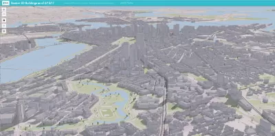
Tim Logan reports on a new digital 3D map produced by the Boston Planning & Development Agency (BDPA) that models the entire city.
The map is "the latest step in the BPDA’s push to be more transparent, and to spark conversations about planning for the city’s future," according to Logan. Previously, BDPA housed a wooden scale model on the ninth floor of City Hall. The new digital map is public, and the hope is that it will inspire the public to engage with the city's development in new ways.
The map maps 129,000 buildings from East Boston to Mottapan, explains Logan. "The map is pannable and scannable, and detailed enough to capture backyard sheds, rooftop furniture, and lots of trees. And it comes with tools that allow anyone to layer on zoning maps, schools, MBTA stops, and even flood-prone areas."
FULL STORY: You can see your home from here. A new 3D map covers the entire city


Boston to Launch New Downtown Plan
The Boston Planning & Development Agency will hire consultants to craft a vision for its rapidly changing downtown.

Boston Gets a New Planning Department
After 67 years since its formation, the Boston Planning and Development Agency is no more.
Boston to Begin Zoning Code Update, Mayor Announces
It’s been nearly 60 years, but the city of Boston is finally ready to do a comprehensive rewrite of its zoning code.

Alabama: Trump Terminates Settlements for Black Communities Harmed By Raw Sewage
Trump deemed the landmark civil rights agreement “illegal DEI and environmental justice policy.”

Study: Maui’s Plan to Convert Vacation Rentals to Long-Term Housing Could Cause Nearly $1 Billion Economic Loss
The plan would reduce visitor accommodation by 25% resulting in 1,900 jobs lost.

Planetizen Federal Action Tracker
A weekly monitor of how Trump’s orders and actions are impacting planners and planning in America.

Waymo Gets Permission to Map SF’s Market Street
If allowed to operate on the traffic-restricted street, Waymo’s autonomous taxis would have a leg up over ride-hailing competitors — and counter the city’s efforts to grow bike and pedestrian on the thoroughfare.

Parklet Symposium Highlights the Success of Shared Spaces
Parklets got a boost during the Covid-19 pandemic, when the concept was translated to outdoor dining programs that offered restaurants a lifeline during the shutdown.

Federal Homelessness Agency Places Entire Staff on Leave
The U.S. Interagency Council on Homelessness is the only federal agency dedicated to preventing and ending homelessness.
Urban Design for Planners 1: Software Tools
This six-course series explores essential urban design concepts using open source software and equips planners with the tools they need to participate fully in the urban design process.
Planning for Universal Design
Learn the tools for implementing Universal Design in planning regulations.
Caltrans
Smith Gee Studio
Institute for Housing and Urban Development Studies (IHS)
City of Grandview
Harvard GSD Executive Education
Toledo-Lucas County Plan Commissions
Salt Lake City
NYU Wagner Graduate School of Public Service