


Looking back to evaluate the potential of the present.
Jonathan O'Connell presents a history of the Washington, D.C. waterfront—made increasingly relevant as the mega-development known as The Wharf continues to take shape.
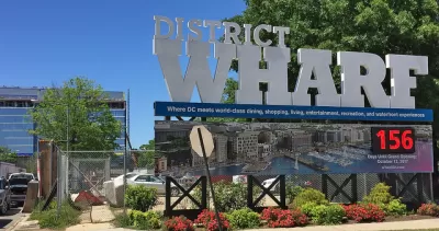
Here's how O'Connell describes the The Wharf, after taking a tour of the property with developer Monty Hoffman back in September, just prior to the opening of the project's first phase.
All told, when the second phase is completed in 2022, there will be a mile of waterfront on 24 acres of land, 50 acres of riparian rights in the channel, 1,375 residences, 945,000 square feet of office space, 800 rooms in four hotels, 2,500 parking spaces, and 10 acres of parks and open spaces.
At a cost of $2.5 billion, the Wharf is one of the most aggressive efforts in recent memory by the District, maybe by any city, to reinvent a waterfront. It also happens to be located near the site of a previous, infamous attempt at urban transformation: In the 1950s, the federal and local governments leveled thousands of buildings in Southwest and, according to the D.C. Preservation League, forced a total of 23,000 residents and 1,500 businesses to move. They then built a mass of brutalist-style housing complexes around a retail center, Waterside Mall. Little remained beyond the Maine Avenue fish market and a handful of churches. Southwest, the boyhood stomping ground of Marvin Gaye, eventually became a case study of everything urban renewal got wrong about cities and people.
Much of the article, however, focuses on the history of waterfront development in Washington, D.C. and the precedent set by the Inner Harbor in Baltimore. The big question O'Connell means to provide context for is whether The Wharf will finally change the narrative of planning and development failures on the waterfront of the nation's capital.
FULL STORY: Do posh waterfronts make a city world-class? D.C. is betting hundreds of millions on it.


Designing for Dementia
Subtle design interventions can facilitate safe navigation in urban environments for people with cognitive abilities effected by dementia.
D.C.'s Wharf Makes the City's Housing Problems Worse
Did The Wharf, a new mixed use mega project in Washington, D.C., deliver enough public benefit to warrant its large public subsidy?
Shared Street Mixes Pedestrians and Cars—Truly Radical
A new development in Washington, D.C. features the largest "shared space" in the United States.

Alabama: Trump Terminates Settlements for Black Communities Harmed By Raw Sewage
Trump deemed the landmark civil rights agreement “illegal DEI and environmental justice policy.”

Planetizen Federal Action Tracker
A weekly monitor of how Trump’s orders and actions are impacting planners and planning in America.

The 120 Year Old Tiny Home Villages That Sheltered San Francisco’s Earthquake Refugees
More than a century ago, San Francisco mobilized to house thousands of residents displaced by the 1906 earthquake. Could their strategy offer a model for the present?

Ken Jennings Launches Transit Web Series
The Jeopardy champ wants you to ride public transit.

BLM To Rescind Public Lands Rule
The change will downgrade conservation, once again putting federal land at risk for mining and other extractive uses.

Indy Neighborhood Group Builds Temporary Multi-Use Path
Community members, aided in part by funding from the city, repurposed a vehicle lane to create a protected bike and pedestrian path for the summer season.
Urban Design for Planners 1: Software Tools
This six-course series explores essential urban design concepts using open source software and equips planners with the tools they need to participate fully in the urban design process.
Planning for Universal Design
Learn the tools for implementing Universal Design in planning regulations.
Clanton & Associates, Inc.
Jessamine County Fiscal Court
Institute for Housing and Urban Development Studies (IHS)
City of Grandview
Harvard GSD Executive Education
Toledo-Lucas County Plan Commissions
Salt Lake City
NYU Wagner Graduate School of Public Service