


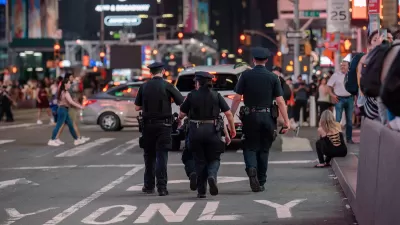
The NYPD vaunts crime mapping technologies from CompStat maps to a vast networked surveillance infrastructure. Who benefits?
A multi-billion-dollar industry of data-driven policing technology includes dozens of mapping, surveillance, and data-analysis tools, each claiming to hone in on crime at ever-finer grain. But as data and infrastructure writer Ingrid Burrington argues, these technologies represent less a science for the provision of safety, and more a highly effective sales pitch for a management model born in the zero tolerance Giuliani era. Since the early 1990s, when precinct commanders pushed pins into paper maps, police in New York have contended that if they can track crime, then they can predict it, and therefore prevent it. The maps they’ve made have monopolized media narratives, and shaped the lives of those who live within their frames. The authors of CompStat now export their methods around the world. Business is good for those technology vendors and consultants who sell crime- and fear-reduction as a customer service. But who’s buying? More than a set of tools, crime mappers hawk a model of a future world where the cost of guaranteed order would be accountability to the public.
FULL STORY: Policing is an Information Business

Security Cameras to Invade Manhattan
In the wake of an attempted car bombing in New York City's Times Square, officials are calling for the expanded use of security cameras throughout Manhattan.
Over 90 Percent of NYC Jaywalking Tickets Issued to Black and Latino Pedestrians
The city’s police force continues its history of disproportionately citing people of color for illegal street crossings.

Study Assesses Attitudes on Traffic Cameras in Boston’s Black Communities
Residents are wary of the new technology’s potential for surveillance, but support boosting enforcement while reducing interaction with police.

Alabama: Trump Terminates Settlements for Black Communities Harmed By Raw Sewage
Trump deemed the landmark civil rights agreement “illegal DEI and environmental justice policy.”

Planetizen Federal Action Tracker
A weekly monitor of how Trump’s orders and actions are impacting planners and planning in America.

The 120 Year Old Tiny Home Villages That Sheltered San Francisco’s Earthquake Refugees
More than a century ago, San Francisco mobilized to house thousands of residents displaced by the 1906 earthquake. Could their strategy offer a model for the present?

Ken Jennings Launches Transit Web Series
The Jeopardy champ wants you to ride public transit.

BLM To Rescind Public Lands Rule
The change will downgrade conservation, once again putting federal land at risk for mining and other extractive uses.

Indy Neighborhood Group Builds Temporary Multi-Use Path
Community members, aided in part by funding from the city, repurposed a vehicle lane to create a protected bike and pedestrian path for the summer season.
Urban Design for Planners 1: Software Tools
This six-course series explores essential urban design concepts using open source software and equips planners with the tools they need to participate fully in the urban design process.
Planning for Universal Design
Learn the tools for implementing Universal Design in planning regulations.
Clanton & Associates, Inc.
Jessamine County Fiscal Court
Institute for Housing and Urban Development Studies (IHS)
City of Grandview
Harvard GSD Executive Education
Toledo-Lucas County Plan Commissions
Salt Lake City
NYU Wagner Graduate School of Public Service