


The city of Milwaukee has renderings to illustrate its ambitions for transit oriented development surrounding the streetcar extension into Bronzeville and Walker's Point.

"The City of Milwaukee has released conceptual renderings of how extending the streetcar system to Bronzeville and Walker’s Point could change both neighborhoods," reports Jermey Jannene.
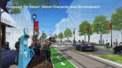
The renderings, released to the public at a recent public hearing, depict streets with a full suite of complete street and traffic calming infrastructure. Jannene summarizes the depictions:
In Walker’s Point, the renderings depict empty lots on a traffic-calmed S. 1st St. being developed into mid-rise buildings and continued activation of S. 2nd St. following the street’s 2010 narrowing. A greenway, a street that encourages cycling over high-speed driving, is proposed for Washington St. that would better connect Walker’s Point and the Harbor District to neighborhoods to the west for cyclists. A similar proposal, sometimes called a bike boulevard, is in the works for Riverwest.
A rendering for Bronzeville depicts N. Martin Luther King Jr. Dr. receiving new development in context with existing buildings on the street. Traffic calming, green-painted bike lanes and medians are all depicted.
Click through to see the full set of renderings and also check out websites for the city's ongoing planning efforts regarding King Drive and the neighborhoods of Bronzeville and Walker's Point as well as the Milwaukee Streetcar.
FULL STORY: Renderings for Streetcar Extensions

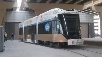
'The Hop' Streetcar Opens to the Public Today in Milwaukee
The Hop will deliver new transit service on the east side of downtown Milwaukee. The Hop comes also serves big development expectations from local officials.
Land Use Planning Precedes Streetcar Extension in Milwaukee
Plans to extend Milwaukee's The Hop streetcar line are still years away from fruition, but the city is already at work on development plans to make the most of the opportunity.

Why Free Rides on the Milwaukee 'Hop' Streetcar Are a Bad Idea
Citing the psychological impact of doughnuts and the American Red Cross, one opinion writer questions the wisdom of a recent sponsorship deal.

Alabama: Trump Terminates Settlements for Black Communities Harmed By Raw Sewage
Trump deemed the landmark civil rights agreement “illegal DEI and environmental justice policy.”

Planetizen Federal Action Tracker
A weekly monitor of how Trump’s orders and actions are impacting planners and planning in America.

The 120 Year Old Tiny Home Villages That Sheltered San Francisco’s Earthquake Refugees
More than a century ago, San Francisco mobilized to house thousands of residents displaced by the 1906 earthquake. Could their strategy offer a model for the present?

In Both Crashes and Crime, Public Transportation is Far Safer than Driving
Contrary to popular assumptions, public transportation has far lower crash and crime rates than automobile travel. For safer communities, improve and encourage transit travel.

Report: Zoning Reforms Should Complement Nashville’s Ambitious Transit Plan
Without reform, restrictive zoning codes will limit the impact of the city’s planned transit expansion and could exclude some of the residents who depend on transit the most.

Judge Orders Release of Frozen IRA, IIJA Funding
The decision is a victory for environmental groups who charged that freezing funds for critical infrastructure and disaster response programs caused “real and irreparable harm” to communities.
Urban Design for Planners 1: Software Tools
This six-course series explores essential urban design concepts using open source software and equips planners with the tools they need to participate fully in the urban design process.
Planning for Universal Design
Learn the tools for implementing Universal Design in planning regulations.
Clanton & Associates, Inc.
Jessamine County Fiscal Court
Institute for Housing and Urban Development Studies (IHS)
City of Grandview
Harvard GSD Executive Education
Toledo-Lucas County Plan Commissions
Salt Lake City
NYU Wagner Graduate School of Public Service