


It was the city's "first major regulatory response" to Hurricane Harvey.
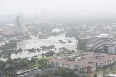
Last week, in an "unusually tight" vote, the Houston City Council ruled that starting in September, "all new construction in the city’s floodplains will have to be built two feet above the projected water level in a 500-year storm." Under current rules, it's only one foot, and from only the 100-year level.
"The vote marks a shift away from Houston’s longtime aversion to constraining," writes Rebecca Elliot, who also reports that the vote was largely along party lines—as well as supported by the mayor.
Harris County started using the 500- year floodplain in January, but entire region's distaste for regulation has been a popular topic of conversation in the months since Hurricane Harvey, which according to some studies was more like a 1,000-year storm.
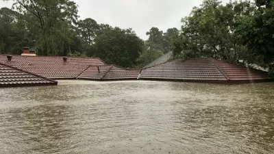
It might seem unwise, after Harvey, tokeep building in the floodplain at all, but the city's real estate market barely paused in the wake of the massive storm, and buyers of both new and old structures will still be protected by the National Flood Insurance Program.
FULL STORY: City Council adopts stricter development rules for Houston’s floodplains

800 New Homes Approved for Houston's Floodplain
The city of Houston approved a new development that doesn't meet new elevations standards approved by the city of Houston earlier this month.
Houston-Area Floodplain Regulations to Expand from 100-Year to 500-Year Levels
Harris County, home to Houston and the scene of widespread devastation during Hurricane Harvey and other weather events, will make large-scale changes to development regulations on floodplains for the first time in almost 20 years.
Connecting the Issues of Flooding and Affordable Housing in Texas
A study released this week by the Greater Houston Flood Mitigation Consortium ( the University of Houston, the Kinder Institute, the Local Initiatives Support Corporation, and more) raises concerns that new floodplain regulations could harm renters.

Alabama: Trump Terminates Settlements for Black Communities Harmed By Raw Sewage
Trump deemed the landmark civil rights agreement “illegal DEI and environmental justice policy.”

Planetizen Federal Action Tracker
A weekly monitor of how Trump’s orders and actions are impacting planners and planning in America.

The 120 Year Old Tiny Home Villages That Sheltered San Francisco’s Earthquake Refugees
More than a century ago, San Francisco mobilized to house thousands of residents displaced by the 1906 earthquake. Could their strategy offer a model for the present?

Ken Jennings Launches Transit Web Series
The Jeopardy champ wants you to ride public transit.

BLM To Rescind Public Lands Rule
The change will downgrade conservation, once again putting federal land at risk for mining and other extractive uses.

Indy Neighborhood Group Builds Temporary Multi-Use Path
Community members, aided in part by funding from the city, repurposed a vehicle lane to create a protected bike and pedestrian path for the summer season.
Urban Design for Planners 1: Software Tools
This six-course series explores essential urban design concepts using open source software and equips planners with the tools they need to participate fully in the urban design process.
Planning for Universal Design
Learn the tools for implementing Universal Design in planning regulations.
Clanton & Associates, Inc.
Jessamine County Fiscal Court
Institute for Housing and Urban Development Studies (IHS)
City of Grandview
Harvard GSD Executive Education
Toledo-Lucas County Plan Commissions
Salt Lake City
NYU Wagner Graduate School of Public Service