


Satellite images make some of the best maps.
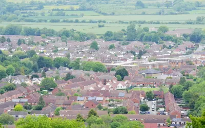
A post on the website of the Local Authority of Building Control (LABC) in the United Kingdom has produced a new map that uses high definition satellite images to plot the different kinds of land development in the United Kingdom.
The maps were created with Corine (coordination of information on the environment) Land Cover data from 2012 which includes 44 different types of land classification including:
- ‘continuous urban fabric’: used to describe the most built up urban areas
- ‘industrial and commercial units’
- ‘green urban’: golf courses, football pitches, parks etc
- ‘farmland’: pasture, arable land, vineyards, orchards
- ‘natural’: moors, forests, lakes
According to the article, the "continuous urban fabric" designation, which applies to areas where 80-100% of the land surface is built on, only accounts for o.1 percent of the land in the United Kingdom. "Another category called 'discontinuous urban fabric', places where between 50% and 80% of the land surface is built on accounts for a mere 5.6%."
Hat tip to H. Pike Oliver for sharing the link to the LABC's post.
FULL STORY: UK land use laid bare by satellite images


Commentary: Why We Need a Federal Definition of ‘Rural’
A patchwork of definitions of rural versus urban areas has real consequences for communities seeking federal funding.

How the Built Environment Affects Your Mood
Humans have survived for millennia by staying together, not apart.

Opinion: Ohio Needs Public Transit
A new Intel facility is set to bring thousands of workers to rural Ohio. Will the state embrace mass transit or give in to auto-centric sprawl?

Alabama: Trump Terminates Settlements for Black Communities Harmed By Raw Sewage
Trump deemed the landmark civil rights agreement “illegal DEI and environmental justice policy.”

Planetizen Federal Action Tracker
A weekly monitor of how Trump’s orders and actions are impacting planners and planning in America.

The 120 Year Old Tiny Home Villages That Sheltered San Francisco’s Earthquake Refugees
More than a century ago, San Francisco mobilized to house thousands of residents displaced by the 1906 earthquake. Could their strategy offer a model for the present?

Indy Neighborhood Group Builds Temporary Multi-Use Path
Community members, aided in part by funding from the city, repurposed a vehicle lane to create a protected bike and pedestrian path for the summer season.

Congestion Pricing Drops Holland Tunnel Delays by 65 Percent
New York City’s contentious tolling program has yielded improved traffic and roughly $100 million in revenue for the MTA.

In Both Crashes and Crime, Public Transportation is Far Safer than Driving
Contrary to popular assumptions, public transportation has far lower crash and crime rates than automobile travel. For safer communities, improve and encourage transit travel.
Urban Design for Planners 1: Software Tools
This six-course series explores essential urban design concepts using open source software and equips planners with the tools they need to participate fully in the urban design process.
Planning for Universal Design
Learn the tools for implementing Universal Design in planning regulations.
Clanton & Associates, Inc.
Jessamine County Fiscal Court
Institute for Housing and Urban Development Studies (IHS)
City of Grandview
Harvard GSD Executive Education
Toledo-Lucas County Plan Commissions
Salt Lake City
NYU Wagner Graduate School of Public Service